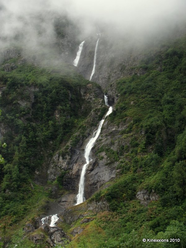
 One of the streams/waterfalls that drop hundreds of feet down the mountain side along the Glacier Highway.
Halfway to Stewart the valley expanded once more. A first glimpse of Stewart, in the rain and early evening twilight, was not impressive. It looked drab and run-down. I passed by an RV Park and went on to the Municipal Campground, which was in a heavily forested area. It looked dark under the trees even though it was still early evening. But it offered flush toilets and hot showers, so it got the nod for the night!
==========
Tuesday, August 31st - - Stewart didn't look much better when I drove through town this morning. It was drizzling rain and it was foggy. Visualize a small town in America in the 1950s then move forward 60 years but make no changes to the town. Old buildings add character to a place but most of these buildings were way past their prime.
I stopped at the Visitor Center, which appeared to be one of the newest buildings in town, and picked up a self-guiding car-tour map of the road that goes to Hyder, Alaska and which continues on to Salmon Glacier. I was informed by the nice lady that it is a dirt road but once you get through Hyder and beyond the Bear Viewing Platform and get back into British Columbia, the road is well maintained and in good condition. The implication was that the U.S. portion of the road wasn't in good shape. Well, it wasn't implied, she came right out and said that the U.S. portion of the road was terrible! It had potholes and washboard areas and was narrow in spots – but it was only for a couple of miles. It's safe, she said, just take it easy.
Throwing caution to the wind, I drove up that road. Slowly and carefully, taking it easy. I've avoided traveling on dirt/gravel roads as much as possible. I just don't like them. But sometimes you have to risk it and hope that the risks are worth the rewards. They were.
Hyder, Alaska (four miles from downtown Stewart) is a small town of 100 happy souls, and one old grouch. So says a sign on one of the old, rugged buildings. The dirt road, the rain, and the fog didn't add much to the appeal of the place. There were about 20 old buildings (some were in use as small shops) and two RV Parks along with a Post Office and a General Store.
I stopped at the Bear Viewing Platform (about 3 miles from Hyder) that is managed by the National Forest Service. No bears were in sight and none had been seen yet today. The Ranger said a mother with her cubs usually comes in about noon and again about six o'clock. It was only nine so I continued on to Salmon Glacier seventeen miles further up the road.
Six miles from the Bear Viewing Platform, I crossed back into British Columbia. And the road got considerably better, as promised. All this time the road is going up. And it keeps going up as well as winding itself around the side of the mountain. And it is still drizzling rain. Ten miles further there is a turnout and I get my first look at Salmon Glacier. Splendid!
 The river of ice fills the valley below and continues on up and around the mountain peak on the left. Those black streaks are dirt and rocks that the glacier has picked up as it moves imperceptibly over the mountains.
It would not be an easy task, if even possible, to hike over this.
 Crevasses and holes would make it a rather treacherous journey. These aren't just ripples in the surface, they are deep. Perhaps a hundred feet or more.
 Salmon Glacier from another turnout two miles north. The clouds and fog obscured the little bit of sun that occasionally came through.
 The Salmon Glacier is the fifth largest glacier in Canada and is a remnant of the last glaciation period which occurred 14,000 years ago. What I saw and what is shown here are but a very small portion of the glacier which extends way back beyond the horizon.
 The sun did make an appearance now and then and the rain finally stopped - briefly. Down in the valley and a few miles to the south are the towns of Hyder, Alaska and Stewart, British Columbia.
Even more slowly than going up, I made my way back down the mountain. I stopped at the Bear Viewing Platform for about 45 minutes. Saw a lot of Chum Salmon in the river, both dead and spawning, but no bears. And the sun was, once more, hidden by the clouds.
I returned to Cassiar Highway and the long drive south, stopping at the town of Smithers for the night. And the rain? It seems that it was the first that Stewart/Hyder had seen in two months! And it followed me to Smithers where I learned that they too hadn't had rain for many weeks.
1 comment:
Still reading, still saying a lot of WOWS!!
Post a Comment