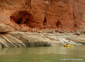
Vasey's Paradise at Mile 32 is named after G. W. Vasey, a botanist who traveled with John Wesley Powell in his first expedition of the Colorado river in 1869.The waterfall is created by water that seeps through the upper sandstone layers of the canyon. The water gathers in the harder rock layers below then flows out from the cliff face through holes in the canyon wall. It was just a narrow trickle of water on the right, but under better conditions (lots of rain or spring snow melt) there would be more water flowing, including a large cascading waterfall on the left.
From the river, Redwall Cavern between mile 33 and 34, doesn't appear to be much more than a nice sandy beach at the base of a towering canyon wall.
Appearances can be deceiving. Once you get out of the raft and start walking into the cavern you begin to get a feel for the enormous expanse that it encompasses.
The photo above, courtesy of Jeff whose GoPro camera has a very wide angle lens, shows it better than any of the shots I took. However, photos truly don't do it justice. To say that it is huge is an understatement! Golf clubs (using "soft" golf balls) and horse shoes mysteriously appeared and we enjoyed lunch here. It was truly a remarkable feature in the canyon.
Looking out from inside Redwall Cavern.
Moving on down the river.
Above and below are some of the many features we would see along the walls of the canyon.
Looking down on the river from the proposed Marble Canyon Dam site between mile 39 and 40.
At the entrance to one of the tunnels dug for the Marble Canyon Dam. It was one of several proposed sites for dams to be built on the Colorado River back in the 1950s. Thankfully, the project was abandoned although the subject still comes up now and then.
We entered the black hole with a few flashlights, carefully watching our step, and walked a short distance inside. We stopped when we got to the point where the main tunnel split up into four (I think) other tunnels. There was also a "tunnel" that had been drilled straight up! It was wet, dark, and dank inside so we didn't stick around long.
Another cave-like feature in the canyon wall.
A short distance beyond mile 43, the 600 foot high canyon wall conceals an ancient relic within its black algae-covered facade.
Discovered in the 1970s, the Anasazi Bridge is more than 1100 years old. Just imagine what it would have been like to carry the logs and other materials up to the site to build a bridge to cross that crevasse. Back-breaking. Dangerous. An incredible feat.
Our campsite at Eminence Break was just around the bend.
~ ~ ~ ~ ~ ~ ~ ~ ~ ~
Note: The page Grand Canyon Raft Trip lists all of my posts published about this Grand Adventure!
Published under a Creative Commons License.
Becky Wiseman, "Day 3 on the Colorado River - Mile 26.5 to Mile 44.5," Kinexxions, posted October 29, 2014 (http://kinexxions.blogspot.com/2014/10/day-3-on-colorado-river-mile-265-to.html : accessed [access date])


1 comment:
So Awesome and Beautiful.
Post a Comment
The ability to comment has been turned off for all blog posts effective 21 May 2018. Kinexxions has been inactive for more than two years and most comments have come to me directly via email from readers but more than a few were simply spam. My desire is to keep the blog available to the public since there is value in what has been published, particularly posts dealing with family history.
I am still extremely interested in hearing from readers who might be related and have questions or simply want contact with a distant cousin. Please contact me directly via email at kinexxions@gmail.com
This action is also being taken partially due to the General Data Protection Regulation aka "GDPR" going into effect on 25 May 2018. Even though it is a regulation implemented by the European Union that primarily affects businesses and corporations, it governs how data about people can be used. That includes comments left on blog posts, thus the ability to comment is no longer available.
Becky Wiseman - - kinexxions@gmail.com
Note: Only a member of this blog may post a comment.