Showing posts with label Texas. Show all posts

Sunday, March 17, 2013

Out of Texas... into New Mexico... and Beyond

After departing Big Bend National Park on March 3rd, I traveled about 100 miles northwest to Fort Davis, just as I had done three years ago. Once again I stayed at the Davis Mountains State Park for nearly a week. And, once again I did pretty much the same things as then but there were no hikes or even pretty sunsets.

Leaving Fort Davis on March 10th I made it into New Mexico, traveling west through El Paso and north to Alamogordo, stopping for the night at Oliver Lee Memorial State Park. It was extremely cloudy in the north as I drove out of El Paso giving me hopes of seeing a nice sunset. There were several layers of clouds that blanketed the sky when I arrived but within an hour they were gone! It was amazing to me how quickly the clouds disappeared.

My Campsite, looking toward the east.

A fun and rather dramatic shot of Van Dora and the mountains in the background.

 The think layer of clouds that blanketed the area when I arrived gave way to puffy cumulus clouds and blue skies.

 By the time the sun was setting, the clouds in the west had blown away.

The mountains to the east caught the last golden rays of the setting sun.

In the intervening week, I ventured into the north and western parts of New Mexico, primarily because I had never been there before and actually ended up in Colorado briefly. I'll have more photos posted in the next few days.

When I left Indiana, I had planned on eventually spending some time in Salt Lake City again. That time has come... the last three days were primarily spent driving (and driving), and I have arrived in Salt Lake City. I've also registered for RootsTech and hope to see many of my genea-blogging friends this week.

Published under a Creative Commons License.
Becky Wiseman, "Out of Texas... into New Mexico... and Beyond," Kinexxions, posted March 17, 2013 (http://kinexxions.blogspot.com/2013/03/out-of-texas-into-new-mexico-and-beyond.html : accessed [access date])

Wednesday, March 13, 2013

Big Bend Revisited :: Boquillas Canyon Trail

Sunday, March 3rd - - On my last day at Big Bend, I decided to hike the Trail to Boquillas Canyon, going in mid-morning to avoid the heat that was coming later. It was forecast to get near 90 degrees today, the hottest day yet.

It is a short trail - only 1.4 miles round trip - but it takes you up a rather large hill, then back down the other side.

The trail provides some nice views. Blending into the distant landscape is the the town of Bouquillas. If you look closely you can see a few white buildings in the center of the photo, just beyond the green area. Actually, the town is not far from the Rio Grande Village area.

One of the many bends in the river. The man in the foreground was fishing. I wonder if he caught anything?

On my previous visit in February 2010 I had the pleasure of hearing "Victor, the singing Mexican" but he was on the other side of the river then. There were several bottles set out along the trail, asking for donations for singing. Some bottles were identified as Jesus, others as Victor. This man was standing beside one of the bottles identified as Victor but when I asked his name, he said Jesus! Anyway, while I was in the canyon area, I was being serenaded.

The path leads you to the river... 

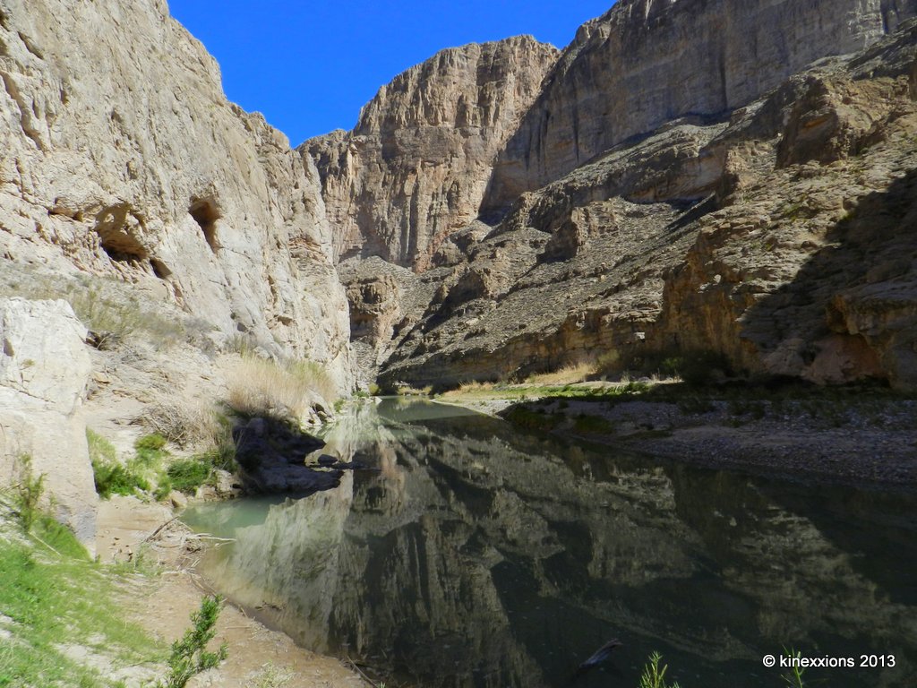
The canyon walls go straight up, and the river disappears around the bend.

It was cool in the canyon, but as I walked back out, I could feel the heat. It was indeed going to be a hot day and it felt good. A few of the buildings in the town of Boquillas can be seen in the far right corner of this photo. As always, double-click to view a larger version.

Published under a Creative Commons License.
Becky Wiseman, "Big Bend Revisited :: Boquillas Canyon Trail," Kinexxions, posted March 13, 2013 (http://kinexxions.blogspot.com/2013/03/big-bend-revisited-boquillas-canyon.html : accessed [access date])

Tuesday, March 12, 2013

Big Bend Revisited :: Cerro Castalon

Saturday, March 2nd - - In English, Cerro Castalon is called Castolon Peak. Whatever you call it, it dominates the landscape in the Castalon region in the southern realms of Big Bend National Park.

The southern view is the most photogenic side of Cerro Castalon. As you drive in from the north the peak appears from out of nowhere as you crest one of the many hills. The road winds through the area with virtually no place to pull off to get a picture.

On my way back from Elena Canyon, I shot this through the front window, stopping in the middle of the road. There wasn't much traffic... Shooting through the windshield adds a greenish tint to photos so I converted it to black and white and adjusted the contrast a little.

At the base of the peak, on the western side, is a pull-out. This too, is Cerro Castalon though it doesn't look quite so impressive from this vantage point... which just goes to show, you need to look at everything from different perspectives!

Published under a Creative Commons License.
Becky Wiseman, "Big Bend Revisited :: Cerro Castalon," Kinexxions, posted March 12, 2013 (http://kinexxions.blogspot.com/2013/03/big-bend-revisited-cerro-castalon.html : accessed [access date])

Monday, March 11, 2013

Big Bend Revisited :: Santa Elena Canyon

Saturday, March 2nd - - From Rio Grand Village to Santa Elena Canyon is about a 55 mile, very pleasant scenic drive, through the varied terrain of Big Bend National Park. It's worth the drive.


There is not much water flowing through this area of the Rio Grande. On the right you are in the United States, on the left is Mexico. You could easily walk across the Rio Grande, but it is definitely not recommended. In fact, it is illegal to do so.

A trail goes up the canyon wall in a series of short switchbacks on the far right, then takes you on back into the canyon a short distance. The temperature was reaching into the 80s and I had done the hike three years ago so chose not to do it this time.

This is the creek that was full of water during my last visit. You have to cross it to get to the trail. Going across was a bit of challenge then, not so now.

Yep, it was pretty dry. Some of those cracks were 3-4 inches deep.

Published under a Creative Commons License.
Becky Wiseman, "Big Bend Revisited :: Santa Elena Canyon," Kinexxions, posted March 11, 2013 (http://kinexxions.blogspot.com/2013/03/big-bend-revisited-santa-elena-canyon.html : accessed [access date])

Sunday, March 10, 2013

Big Bend Revisited :: Torrey Yucca

Thursday, February 28th - - As I was driving from one place to another, I kept seeing this strange looking plant. It stood anywhere from four to six feet in height. Usually the bottom half was still brown and dry looking, but on the upper portion were long green spikes and a huge flowering head. There are quite a few pull-outs along the park roads but it seemed there weren't any of these plants in those areas. I finally found a pull-out with several of them somewhat near the road, while on my way to Boquillas Canyon.

This is the Torrey Yucca... The University of Texas at Austin website has some information about the plant as well as some pretty neat photos.

Many of the specimens I saw had only one flowering clump adorning the top, but this one, as well as others, are sporting two.

What appears at first glance to be one huge flower turns out to be a clump of many small flowers, in varying stages of development.


Published under a Creative Commons License.
Becky Wiseman, "Big Bend Revisited :: Torrey Yucca," Kinexxions, posted March 10, 2013 (http://kinexxions.blogspot.com/2013/03/big-bend-revisited-torrey-yucca.html : accessed [access date])

Saturday, March 09, 2013

Big Bend Revisited :: Boquillas Overlook

Thursday, February 28th - - It was late afternoon when I drove out to Boquillas Overlook on the east side of Big Bend National Park. The road to Boguillas Canyon is a mile or so from Rio Grande Village. It is a short but somewhat "challenging" drive with lots of twists and turns along the way.

Signs are posted in certain areas of the park regarding Mexicans coming across the river to sell trinkets and craft items "for the support of the Boquillas school." The signs warn you that purchasing these items is illegal. However, there is apparently enough income gained that they continue to present their wares for sale.

 At Boquillas Overlook there were several boulders used for displaying the goods for sale. The sign reads "Art, Craft, for Sale please purchase to Help Boquillas Mexico school kids Donations are aseptable. Walking Sticks - 6, Scokoypions - 6, Road runner - , Ocotillos - 5..."

All of the displays were selling similar items... walking sticks, and scorpions and road runners made from wire and beads.

When I arrived at the overlook, there was a Mexican walking away from the area. He waved, said hello and something else that I didn't understand, then walked down the hill and away toward the river.

I nonchalantly started taking pictures... Looking to the East...

Looking to the West...

And the view to the south... Oh, my - Across the river a boat sits on the shore and to the right, under a clump of trees was a group of men...

A close-up of the men lounging in the shade of the trees. I didn't mention earlier, that another sign at the turn-off to Boquillas Canyon warned of numerous recent vehicle break-ins. We were told to make sure our vehicles were locked and that valuable items were hidden away. I wondered if these were simply men lounging about or were they bandidos? Ah, the mind can take you off into some strange places...

Published under a Creative Commons License.
Becky Wiseman, "Big Bend Revisited :: Boquillas Overlook," Kinexxions, posted March 9, 2013 (http://kinexxions.blogspot.com/2013/03/big-bend-revisited-boquillas-overlook.html : accessed [access date])

Friday, March 08, 2013

Big Bend Revisited :: Chisos Basin

Thursday, February 28th - - It was about 180 miles from Seminole Canyon State Park to the northern entrance of Big Bend National Park. At 10:30 when I finally left Seminole Canyon, the temperature was 57 degrees with a few clouds, lots of blue skies and sunshine.

Once you get to the entrance of Big Bend, it is another 30 miles to the visitor center at Panther Junction, then another 24 miles to the Rio Grande Village area in the eastern side of the park. The road to Rio Grande Village is mostly downhill - it takes you into the "lower" portion of the park - and the temperature went from a cool 60 degrees to a much warmer 69. Yeah, that was nice!

I picked out my campsite, which was to be "home" for the next four nights. The campground was not full by any means and there were plenty of sites to choose from whether you wanted one "out in the open" or more secluded along the southern section (as I did). As usual in most National Parks there are no hookups for electricity or water in the "main" campground. However, Big Bend does have an "RV" area with hookups but it is pretty much a parking lot.

Friday, March 1st - - It got quite cold during the night, as expected, and it sure would have been nice to have a little heater to take the chill out of the air. Instead, I just stayed in the sleeping bag a little longer than usual...

It was still chilly when I finally got up, but it was quite comfortable sitting in the sunshine and eating my breakfast. I decided to drive up to the Chisos Basin area, stopping along the way for some photos...

 Looking to the West, from about 5 miles east of the Panther Junction visitors center.

 Somewhere along the lower portion of the road to Chisos Basin. It's about 8 miles once you turn off the main road to Chisos Basin. The road goes uphill, winding its way through the mountains, gaining several thousand feet in elevation, and making several hairpin turns. The road is not recommended for vehicles pulling trailers longer than 20 feet or for RVs more than 24 feet long.

I don't think there have been any recent bear sightings, but mountain lions were seen in several areas earlier in February. One was even sighted along the Window View Trail not far from the visitors center and the Chisos Lodge.

 Once you get to the highest point along the highway, you then start going down into the basin area. Hidden out of view are the campground and Chisos Mountain Lodge.

 Traveling a little further along the road, the campground area comes into view. I stayed there for five nights on my visit in February 2010. The vehicles look so tiny compared to the mountains surrounding them.

The view through the "window" from the Window View Trail near the visitor center and Chisos Mountain Lodge.

My visit this year would be very different than it was in 2010, and shorter. My legs can't handle the long hikes as well as they did three years ago and I am pitifully out of shape. Nevertheless, the visit this year was very enjoyable and more relaxing, and of course, there will be more posts/photos to come.  Below is a list of the posts from the 2010 visit I thought you might enjoy reading again (or perhaps, for the first time) - I was far more adventurous then!

Published under a Creative Commons License.
Becky Wiseman, "Big Bend Revisited :: Chisos Basin," Kinexxions, posted March 8, 2013 (http://kinexxions.blogspot.com/2013/03/big-bend-revisited-chisos-basin.html : accessed [access date])

Thursday, March 07, 2013

Seminole Canyon :: Revisited

Wednesday, February 27th - - If you are going to Big Bend, and I was, the last "large" town is about six hours away - Del Rio, Texas is the place you want to stock up on supplies and fill up the gas tank!  Del Rio is the home of the Amistad National Recreation Area with a large reservoir that was startlingly low compared to the last time I came through the area, three years ago. There are a few little towns and ranches west along highway 90 but once you get through Del Rio, it appears barren and desolate. Actually, it was pretty much the same from Junction to Del Rio!

About 60 miles west of Del Rio is Seminole Canyon State Park, near Comstock, where I spent the night, as I had done nearly three years ago on February 19th and February 20th.


Private property borders the park and the two are separated by a rather flimsy fence that extends for miles. In-between the metal posts were these "stick" posts that helped support the sagging fence.

The posts were connected very loosely to the fencing with twisted strips of wire. 

It wasn't a "spectacular" sunset, but 'twas very nice.

There was more color, and clouds, in northwestern sky.

Published under a Creative Commons License.
Becky Wiseman, "Seminole Canyon :: Revisited," Kinexxions, posted March 7, 2013 (http://kinexxions.blogspot.com/2013/03/seminole-canyon-revisited.html : accessed [access date])

Wednesday, March 06, 2013

Their Roots are Showing

Friday, February 15th - - Today was a travel day. I left Big Lagoon State Park in Florida and ended up in Monroe, Louisiana  by late afternoon. There I would spend the weekend visiting with my distant Joslin cousins, Sue and Joann (with whom I have traveled in the past), as well as their sisters Missy and Sally, and of course, their mother Ruth. Joann's son, Matt and his two children were also visiting so I had the chance to meet them. Sue wrote about their visit to the cabin - she has some really nice photos of the kids. It was great to see them all again! Thank you, once again, for your hospitality.

Monday, February 18th - - Departed Monroe, Louisiana and traveled westward on Interstate 20 then south to the Martin Dies Jr. State Park a few miles west of Jasper, Texas. The forecast called for rain, and that is what Mother Nature delivered, with intensity at times.

The sky brightened up a bit as the sun was going down, but the break didn't last long - it rained throughout the night.

By morning, the rain and clouds were gone and blue skies were all around. There are two rivers that join together at Martin Dies Jr. State Park. I don't know which one this is but the water was low - perhaps because of the extended drought in Texas the last few years.


If you've ever wondered what the root system of a Cypress tree looked like, now you know! I'm guessing that there is one large "tap-root" that extends further down into the ground that supports each clump of trees.

I traveled further westward and south a bit to South Llano River State Park. Located a few miles south of Junction in central Texas, along Interstate 10. I had picked up a "bug" just before getting to Monroe that got worse as time went on. It started as a sore throat, then  coughing, and then a headache and sinus pressure. I finally gave in after five days and went to a medical clinic in Junction where I was prescribed an antibiotic and cough syrup. Within two days I was feeling much better. Thank you very much!

South Llano River State Park is a nice park. The campground was great, one of the nicer ones in the Texas State park system (in my opinion). The sites are large with lots of space in-between each site. You pick your own site so can select a shaded or sunny site, whichever you desire. It was a good place to simply lounge around and recover from a minor illness. I did take advantage of some of the shorter trails and took a walk most every day. The weather couldn't have been better - well, except for the one day (Monday, the 25th) when the temperature dropped into the 50s and the wind gusted up to 50 mph! That day was mostly spent at the library!

Wednesday, February 27th - - Another travel day. Finally feeling well enough to move on... heading further south.

Wednesday, March 6th - - I know you are wondering - Where am I now? I will say this - I'm still in Texas, just not as far south as I was this past week!

Published under a Creative Commons License.
Becky Wiseman, "Their Roots are Showing," Kinexxions, posted March 6, 2013 (http://kinexxions.blogspot.com/2013/03/their-roots-are-showing.html : accessed [access date])

Friday, December 16, 2011

Padre Island :: Sunset


Another one of my favorite places in Texas – Padre Island National Seashore. Photo taken December 13, 2011 - a delightful 75 degrees! Oh, yeah....

But things are not always what they seem. Apparently the “Red Tide” had invaded the Gulf waters. According to the Texas Parks & Wildlife website it “is a naturally-occurring, higher-than-normal concentration of the microscopic algae Karenia brevis. This organism produces a toxin that affects the central nervous system of fish so that they are paralyzed and cannot breathe. As a result, red tide blooms often result in dead fish washing up on Gulf beaches. When red tide algae reproduce in dense concentrations or "blooms," they are visible as discolored patches of ocean water, often reddish in color.”

I didn't see the Red Tide, but I did see the results.... Along the upper edge where the tide reaches its highest level, the beach was lined with dead fish. Trust me. It was not a pretty site. And the smell? Well, lets just say that it left something to be desired. It really wasn't too bad once you got past the line of dead fish – which included several varieties of Jelly Fish.

According to a pamphlet handed out at the entrance station, Red tide can cause problems with breathing, coughing, sneezing, and teary eyes – especially with windy weather conditions and rough surf – the exact conditions when I arrived and spent a couple hours walking along the beach!

That night I developed a cough and was sneezing quite a bit. I hadn't yet read the pamphlet so just thought it was the cool, damp night air. But it continued to get worse the next day and when I read the material provided at the entrance station I realized what it was. When I left for several hours and went into Corpus Christi, the symptoms abated somewhat. I had already paid for the second night so decided to stay.

The campground (using the term loosely – it was basically a paved parking lot) was just a few feet from the beach somewhat protected by a ridge of dunes. The smell of decaying fish was negligible once you were off of the beach. I enjoyed the sound of the surf hitting the shore and was lulled to sleep with it each night. There is something that can't be explained about that sound. It's primeval. Coupled with watching the waves coming onto the beach, moving in and out... well, it is mesmerizing.

I had planned on staying here at least five days, but with the symptoms I was experiencing, I reluctantly decided to cut my visit short. I'm happy to report that within a few hours (8-10) of leaving Padre Island, the coughing and sneezing stopped ;-)

Thursday, December 15, 2011

A Walk Along the River :: San Antonio

After leaving Davis Mountains State Park (on December 10th), I spent the day driving to San Antonio. The fog wasn't too bad once I left the mountains and got onto the Interstate Highway and I didn't get into any significant rain until about an hour from the city.

I spent three nights in San Antonio with my friend Diana. She is also a Joslin cousin (3rd cousin once removed). Her great grandfather, Luther Joslin, was a brother to my great-great grandmother, Malissa Mariah Joslin Brubaker Bower. Our families made contact for the first time in 1968, lost contact a few years later, then were reunited in 1999 through the wonders of the internet! The folks I'll be staying with in Louisiana for the holidays are also descendants of Luther. Don't you love it when distant family members become friends too?

One evening we ventured down to the Riverwalk for a stroll and supper. All types of Cafes and Restaurants line both sides of the river for a considerable distance. And, of course, the area was all decked out with lights for the holidays.


Trees were wrapped with lights on every branch and all the way to the top!


It was a rather cool evening but not uncomfortable – if you could stay out of the wind!


I hesitated to include this photo since it is out of focus, but I think it provides more of the ambiance of the evening. I actually kind of like it! Just consider it an “impressionistic” rendition of the Riverwalk...

Wednesday, December 14, 2011

Greetings from Texas :: Albeit Somewhat Belatedly

On December 7th I left Arizona, drove through the southwest corner of New Mexico and entered the great state of Texas! Yes, I've been here a week already... I stopped off for a few days at one of my favorite spots in Texas – Davis Mountains State Park – way down in the southwest corner of the state a few miles from Fort Davis.

Mother Nature was still throwing a hissy fit as far as the weather was concerned with colder than normal temperatures. However, there was one very nice day while I was at Davis Mountains – the thermometer actually reached 62 degrees! And there was sunshine and blue skies. It was quite nice, to say the least. Then the clouds and cold temps rolled back in that night... I left Davis Mountains on the morning of December 10th with the area enshrouded in fog and temperatures in the low 30s. The fog and low temps followed me eastward all day long...


Photos taken on December 8, 2011 from the top of Skyline Drive, Davis Mountains State Park. Overlooking the valley below. The campground is nestled between the hills on the left side of the photo.


This past spring and into early summer, parts of western Texas were ablaze with wildfires. Davis Mountains suffered some damage - most of the shrub trees in the upper areas of the park were blackened by fire and there was more extensive damage in the isolated areas.


The sunset wasn't the prettiest I've seen. But it wasn't bad either ;-)