Showing posts with label Kansas. Show all posts

Monday, May 16, 2011

I'm Not in Kansas Anymore!

Tuesday, May 10th - - It never crossed my mind that I'd spend nearly six days in Kansas, much less enjoy most of it! Crossing over into southeastern Colorado the countryside looked much the same as it had in western Kansas. Fields were under cultivation to begin with but as I ventured further south and west there were more vast expanses of prairie.

However, within a few hours, the view changed dramatically. Mountain peaks touched with a dusting of snow could be seen off in the distance. It wasn't long before they loomed much larger and closer. With the change in view came a dramatic change in daytime temperature – from a high in the upper 90s to a high in the mid 50s. Thank goodness that, unlike the air conditioner, the heater in the van works!


West of Walsenburg, Colorado on U.S. Highway 160/285.

My destination for the night was the Great Sand Dunes National Park and Preserve, near Alamosa. I had visited there once before, way back in May of 1979.


This time, Mother Nature was definitely not cooperating with me. The further west I traveled, the cloudier it got. Once at The Dunes, the sun would occasionally peek out from behind the clouds, but even then the lighting wasn't that great. This is the view from my campsite. The base of The Dunes is about a mile and a half distant.


The image above and those following have been modified. I was going to say “enhanced” but that is entirely dependent upon who is viewing the images. Since you aren't going to see the originals, suffice to say that I think these are an improvement over the originals, considering the lighting conditions at the time.


Human figures add a little perspective on the size of these dunes. They (The Dunes) truly are magnificent.


And from what I remember from back in 1979, they are extremely difficult to walk on. I did go out to the base of The Dunes but simply did not have the energy or stamina to go any further. Besides, it was getting late in the evening, a strong wind was blowing, and it was cold!


The quality of light was pitiful, and it was nearly gone, but the views were still awesome even though they can't truly be captured by the camera.

Sunday, May 15, 2011

Skyscrapers of the Kansas Plains

Tuesday, May 10th - - Driving in west-central Kansas, you can't help but notice these tall buildings punctuating the sky. Nearly every community has one, or several. Sometimes they are seemingly in the middle of nowhere, with no town or community nearby; simply in some farmer's field. And, they are almost always near the railroad tracks.

These photos were taken as I was driving (yes, actually driving) west on the K-96, as it was called by the local inhabitants, aka Kansas State Highway 96. The overall bluish cast of the photos and any “blemishes” are caused by shooting the pictures through the windshield. I'm not gonna say how many shots I took that were fuzzy and totally out of focus! But it sure was fun to do...


Another view of the same grain silo as in the previous photo.


Saturday, May 14, 2011

Monument Rocks aka Chalk Pyramids

Monday, May 9th - - Today was a very short driving day. Still heading west, I stopped in Scott City and spent about four hours at the library getting blog posts scheduled and checking weather forecasts for points west. By the time I left the library the temperature was a scorching 95 degrees and the van was like an oven. Driving westward, with the sun beating down on you, and with those high temperatures is not fun. At the library, I had also checked to see where the nearest Dodge dealer was – too far away. Instead, I went about 10 miles north to Scott Lake State Park and got a campsite for the night. In hindsight, I should have just stayed at the library for a few more hours!

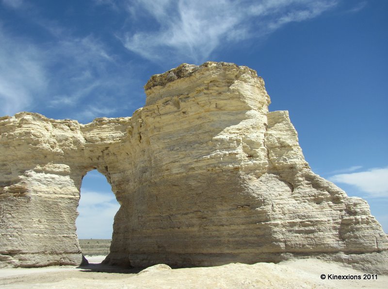
Anyway, looking at the map I saw that a “point of interest” was about 25 miles northeast of the campground. Wanting to “do something” I drove on out to Monument Rocks, also known as Chalk Pyramids. They are visible from US-83, just barely, and if you know where to look. They are on private range land but the owners have made them open to the public and accessible via a 6-mile dirt/gravel road.

Designated as a National Natural Landmark by the U.S. Department of the Interior, the 70-foot tall sedimentary formations were created 80 million years ago when this area was part of a vast inland sea. In 2007, the Kansas Sampler Foundation selected Monument Rocks as one of the Eight Wonders of Kansas. Wish I had found this website sooner- It looks like I missed out on many of the Wonders of Kansas!


There are two “groups” of rocks. These on the east side of the dirt access road and the ones below, on the west side of the road.


The “backside” of the hole in the wall, from the west side group.


For some reason, I found the eastern group to be more interesting.


As you walked around the formations, their character changed. The tall fellow on the left is the same formation that is on the right side of the previous photo.


Part of the eastern group as seen from the south side.


Am I imagining the smiling faces that I see in this group?


My camping site at Scott Lake State Park. Blessed shade and a wonderful breeze that was sometimes way too strong – it kicked up dust devils every now and then! There was a beautiful sunset - I watched the sky change colors as the sun descended below the horizon from the comfort of my campsite – I would have had to have driven outside the park to get a view clear of the trees. But it was a lovely sunset. You'll have to trust me on that!

Friday, May 13, 2011

Central Kansas :: Another Sunset

Sunday, May 8th - - After my brief visit at Mushroom Rock State Park I continued west a short distance to Ellsworth. Then I spent a few hours driving around Russell County, part of which lies north of Interstate 70, and Barton County, which is to the south of Russell County and also south of I-70. You may be asking, Why?

After residing in Iowa for a short time (circa 1866-1868), my third great-grandparents, Lysander and Lydia (Robison) Joslin returned to Whitley County, Indiana. In 1877 they once again sold their land in Whitley County and headed west, this time to Odin, Cheyenne Township, Barton County, Kansas. Here they remained until 1891 when they moved to near Lyndon in Osage County in eastern Kansas.

I really couldn't do research – it was Sunday! Poor timing on my part. I did make a stop at the library in Great Bend for several hours and took a look at some of the books they had. Basically, I simply wanted to see what the countryside was like. The terrain to the north of I-70 differs dramatically from the land that lies to the south, at least in that immediate area. Russell County north of I-70 has hills, large hills. And gullies, deep and big. Southern Russel County and most of Barton County are relatively flat in comparison. Good farming land.

I considered staying in the area another night but decided against it, for various reasons. Instead I continued west on State Road 4 and stopped for the night at Cedar Bluff State Park near the small town of Brownell. It was another hot and windy day, with the temperature nearly reaching 100 degrees. And the air conditioning in the van wasn't working.

The site I had selected was in the shade near the beach. Even in the shade the heat was almost unbearable and I was thankful for the strong breeze that was blowing. My neighbors were a nice young couple. We weren't so lucky with the group that arrived in the early evening. They were loud with the stereo blaring, really inconsiderate. After about 15 minutes I left to find another site (it was a self-serve campground) in another area of the park. The new site turned out to be much better – flush toilets nearby! ;-)

It was also a better campsite because it offered a very nice view of the lake and the sunset, which was once again highly colorful due to the hazy sky. Thankfully, once the sun went down it cooled off considerably!


Thursday, May 12, 2011

Mushroom Rock State Park

Sunday, May 8th - - I passed Mushroom Rock State Park on my way to Kanopolis yesterday and decided to stop on my way out to the main highway.


The park is small, only about five acres, and contains some unusual rock formations, accessed by short trails. This brochure, published by Kansas State Parks describes the formations in detail.


The main attractions of the park.


Erosion will one day weaken the base and the upper rock will come tumbling down.


Graffiti engraved on the lower, softer portion covers the entire base of the rock.


This formation is on the other side of the gravel road that runs through the park.

Wednesday, May 11, 2011

Sunset over Kanopolis Lake

Saturday, May 7th - - After such an exhilerating visit to the Center of the US and the Largest Ball of Twine, I headed south and ended up at Kanopolis State Park. It is located 33 miles southwest of Salina. It was a scorching 95 degrees by the time I arrived – and the air conditioning wasn't working in the van! I found a nice primitive campsite with shade and settled in for a late afternoon nap.

Toward evening, it started cooling down and I went for a walk down toward the lake. There I found just the “right spot” for viewing the setting sun. The skies had been hazy all day and the haze created the perfect atmosphere for an amazingly colorful sunset.


Tuesday, May 10, 2011

A Great Big Ball of Twine

Saturday, May 7th - - Upon leaving Lebanon, if you continue south on Kansas Highway 181 about 20 miles then turn east on Kansas Route 9 and go six miles to Cawker City you'll see it on the right just as you get into town.


“It” is the World's largest ball of twine. In 1988 it had a circumference greater than 40 feet. Another sign on the right proclaims that it was started in 1953 by Frank Stoeber and in 2006 it was composed of 7,801,766 feet of twine weighing in at 17,886 pounds. At the bottom of the sign is Frank's mantra Thrift + Patience = Success.

Kind of makes you wonder about some people! But then, if he was a farmer he had to do something with all of that extra twine left over from baling hay and straw! This particular ball of twine gets more twine gets added each August in a community twine-a-thon.

According to Wikipedia there are even more of these wonders of human endeavors.


Yeah, it's big.


Up close.


And again.


Downtown Cawker City.

Monday, May 09, 2011

The Center of US


Saturday, May 7th - - The above sign is located on U.S. Highway 36 in north-central Kansas. Several miles northwest is the small, rather desolate and forlorn looking town of Lebanon and a little further to the northwest of Lebanon is the Geographic Center of the Contiguous United States.


Going up... on Kansas 191


And over. At the end of the road is “The Center” of the U.S.


This new little chapel seats four. The original was destroyed in 2008 by a speeding car.


The official marker denotes the spot.


The flag really needs to be replaced. A strong wind was blowing as I'm guessing it does much of the time.


Lebanon has souvenirs?