Showing posts with label Arizona. Show all posts

Monday, September 15, 2014

Where Have I Been?

My apologies. I have not been keeping y'all up to date very well, have I? So far this trip I've had internet access just one day. It's been kind of nice being "disconnected" from the world for a while. I've been keeping to the "back roads" of America and not eating at 'that' fast-food joint...

Today is a prep day and a day of relaxing. Sorting through 'stuff' to make sure everything that will be needed in the next 17 days is at hand and hoping that what I've decided to take will all fit in the 'dry bag' that will be provided. Tomorrow we head up to Lee's Ferry for the night with departure Wednesday morning. Excitement is in the air!

Below are some pictures of the places I've been in the past week.  More to come later...

Great Sand Dunes National Park northeast of Alamosa, Colorado.

Black Canyon of the Gunnison (Colorado).

And there was more than cows on the road... poor Van Dora was in need of a bath after this stretch of highway...

A Ranger pointing out the petroglyphs on a guided tour at Hovenweep National Monument (in Utah, west of Cortez, Colorado).

Early evening in Grand Canyon National Park, Arizona.
~ ~ ~ ~ ~ ~ ~ ~ ~ ~
Note: The page Grand Canyon Raft Trip lists all of my posts published about this Grand Adventure!

Published under a Creative Commons License.
Becky Wiseman, "Where Have I Been?," Kinexxions, posted September 15, 2014 (http://kinexxions.blogspot.com/2014/09/where-have-i-been.html)

Tuesday, March 20, 2012

The Grand Canyon :: Navajo Point and Desert View


Navajo Point is the last viewpoint before arriving at Desert View. Quite Spectacular. Indeed.


And a closer view of The River.


And this is how it looks from Desert View. The exterior of the Watch Tower was being renovated the last time I was here and this area was not accessible. I think the little blue wheelbarrow adds something to the picture, I'm just not sure what!


A slightly closer shot of the same view as above.


Each one of the stones used in construction of the Watch Tower was reportedly selected by the architect Mary Jane Colter. She also determined where each stone was to be placed.


I did go inside and was going to go up but after the first few steps, my legs cried out “no way” so I turned around. I was completely enthralled by the interior and took plenty of photos the last time, which you can see here.


The view to the east, looking out over the desert. The Little Colorado Gorge lies a few miles away and the terrain is still quite rugged.

And so, as the road to Desert View comes to an end, so too does this Journey of mine... I've made it safely back to Indiana. I'm Home Again. Thank you to everyone who has followed along, I'm so glad you could join me for the ride...

For those of you who are feeling the need for a bit of adventure, my cousins Sue & Fred will be hiking into the Grand Canyon in a few weeks. Then they will be traveling in the West and in May will follow the coast north and “driving” to Alaska via the Marine Highway. They will be spending the Summer Up North! I wish them well in their journey and will be following along virtually, as many of you have been following me...

Monday, March 19, 2012

The Grand Canyon :: Moran Point & Hance Rapids


At Moran Point, I parked on the east side of the parking lot, and as I got out of the van this was what I saw! The Colorado River can be seen more frequently on the eastern side of the park because the canyon walls are not quite so steep.


Walking to the western side of the viewpoint, the view was even more breathtaking. If you look closely a little to the right of the center of the picture you can see the Hance Rapids. (Better seen if you double-click on the image to get a larger version.)


There was an area to the left and below the viewing area that provided a better view. The lighting was fantastic and really showed off the colors of the Canyon.


Zooming in a little closer... A small tour group showed up while I was there and the guide explained that the Hance Rapids were the largest in the Canyon. He said the waves were 12-15 feet high and the rapids were 200 feet across! Wherever a tributary joins the Colorado there will be rapids, partly from the debris carried into the river by the tributary.


The camera set at the maximum 30x zoom and from a slightly different angle. It looks a little “rough” but still doesn't look like the waves are all that big. Like many things in life, it's just a matter of perspective...

Sunday, March 18, 2012

One Last Chance...

Thursday, March 15th - - As I was driving east along Interstate 40 I decided to take the time to visit one of my favorite places – after all, I might not get back this way again, at least not any time soon. The Grand Canyon is only about 60 miles north of I-40 and it was simply not possible for me to pass it by, especially after I checked the weather report and found that it was going to be a beautiful day!

It was about 11:30 in the morning when I arrived to find the parking lots nearly full. I certainly wasn't expecting that!


Like most visitors, the first place I went was to Mather Point. As you can see, it was a bit crowded.


But the view from Mather Point is worth bumping elbows with other visitors or having to wait until someone moves away from the railing so you can get that “perfect” shot. The weather could not have been better. The temperature was in the low 60s and there was barely a breeze blowing. Also, the “blue haze” wasn't too bad either.

Because there were so many people and I had only a few hours, I decided to skip the western end of the rim trail. You had to walk or take the shuttle buses to see that side of the canyon and I had walked much of it the last time I was here. Instead, I went to get some lunch and then take the drive along the road to Desert View at the eastern end of the park.

While in the cafeteria line I learned why there were so many people here – it's Spring Break! I should have known but the thought just never crossed my mind.

It was a leisurely drive to Desert View (over four hours to drive 30 miles!) with stops at nearly every viewpoint along the way and spending as much time as desired at each one. The further along the drive, the fewer people there were. I took lots of pictures, but I also took time to simply sit in the sunshine and enjoy the gorgeous day and the awesome views.


The view from Grandview Point near the beginning of Desert View Drive.


This tree is amazing. Beyond words.


It looks so close, but 'tis far away. I think that foreground area is Cedar Ridge!

There will be a few more posts on my short visit to the Grand Canyon... so many pictures, and such a beautiful day!

Friday, March 16, 2012

Homeward Bound...

Not quite two years ago (April 5, 2010) after I had been on this Journey for seven months, Craig Manson asked me “How long will you be traveling?” My response was “Till I’m done!” Well, folks, I'm done! And I'm tired...

I woke up last Saturday morning with the realization that I didn't want to go to California. I didn't want the hassle and stress of driving in the horrendous traffic. I just didn't want to deal with any of it. This may sound absurd, but anywhere I'd want to go in California, I've already been. Besides, I'm tired. Yes, there are a few people I'd like to have visited – cousins and friends – but, quite frankly, the traffic and dealing with the weather have taken it's toll. I'm done! And I'm tired...

So, I spent a few days in northwest Arizona mulling things over, trying to determine if this was just a little funk I was in. But it wasn't. I really don't want to go anywhere else either. It's too early to go north and the arid southwest seems, well, quite honestly, not all that appealing right now. Besides, I'm done! And I'm tired...

It has been a marvelous Journey. I can still feel the cold spray of water falling on my face at Niagara Falls and the brisk morning air of that first fall in Vermont. I can see the stillness of the ocean while kayaking in Belfast Harbor and smell the ocean air after a storm at Kennebunk Beach. I see the fog rising from the valleys of Shenandoah National Park, and the sunsets. Oh! The Glorious Sunsets!

I can smell the decaying leaves in the “rain forest” and feel the “sponginess” of the earth beneath my feet in Olympic National Park. I was awed by Mount Rainier and amazed at the deep blue color of Crater Lake. From east coast to west coast and so many places in between. The things I've seen. The things I've done. I went halfway down into the Grand Canyon – and made it back up to the Rim! I went up to the top of Angels Landing – and safely down again. And Alaska! I drove to Alaska! Can you believe it? So many thoughts are going through my mind, so many memories, so many wondrous sights. In one sense, yes, it is over. But in another sense, it will never be over...

But the fact is, it is done. It is time to go home. Back to Indiana. There is a part of me that is sad because it's over. But there is a bit of relief as well. It's time to move on to the next phase, whatever it might be.

But that doesn't mean my traveling days are forever over... I still have a research trip to take into Ohio, Pennsylvania, Maryland, and maybe New York. If not this summer, then next. Depending upon how long it takes me to sort through all of the documents I scanned at the Family History Library! And I'm trying to talk my cousin Babs into taking that “Joslin Heritage Tour” that had to be canceled. When that will happen depends upon her schedule.

In my post announcing this Journey on August 3, 2009 I wrote
I believe in serendipity. Not just in family research, but in travel also. As one door closes, another opens… one phase ends, another begins. I'm a little nervous and a lot excited about the prospects of this journey but I feel it is the right thing for me to be doing at this particular time. The stars have aligned. It's time to go.
Yes, I do believe. It is time to go. Home.

However, it's not quite over, yet. I've still got 1750 miles to go and I did make one last “touristy” stop yesterday...

Sunday, January 22, 2012

Up and Away :: Evening Version

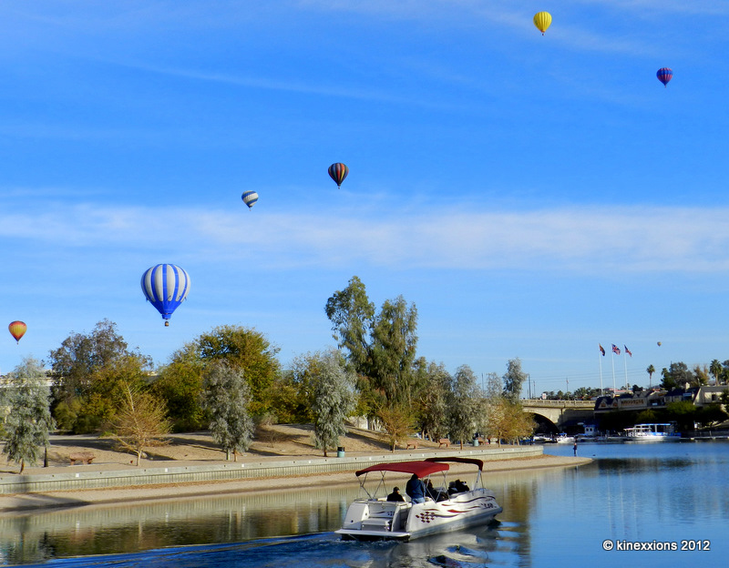
Depending upon the weather, mass ascensions of the balloons are held in the morning and in the early evening. About five o'clock I made my way back to Rotary Park. I could see a bunch of balloons already in the sky and it was an impressive sight!


Even more impressive was seeing the balloons floating just a few feet above the surface of Lake Havasu. Wouldn't it have been fun to be a passenger in either one of the boats or one of the balloons?


There were reportedly six unusually shaped balloons at the festival. This cute little fish is the only one that came close enough so that I could get a nice shot.


Looking to the west, more balloons were ascending. I counted about 40 all in the air at the same time, though not close enough together that you could get them all in one picture.


Another pilot showing off!


For a few brief moments, the sun came out from behind the clouds and the southeastern sky lightened up considerably. I made my way south, toward that spit of land jutting into the lake.


Several balloons landed there but many others continued on further, landing on the southeastern shore of Lake Havasu.


Meanwhile, there were still quite a few balloons drifting off into the western sky.


Carnival rides and other festival activities carried on into the evening, but I did not! I stayed around a few minutes longer, watching the “glow” of some of the balloons still moored on the island.


I also spent a few minutes simply enjoying the awesome sunset that Mother Nature provided for the ending of another beautiful day!

A note about the two photos of the balloons with the golden sky: Those two shots were taken with the camera at the maximum 35x zoom setting and about 20-30 minutes prior to the sunset photo. I made no changes or color corrections to those shots (or any others, for that matter though several had adjustments to contrast and lightness).

Saturday, January 21, 2012

Up and Away :: Morning Version

Friday, January 20th – The campground where I am staying is a reasonable drive from Lake Havasu City. Having seen several signs indicating that a Balloon Festival is in progress this weekend, I got up at (what is for me) an early hour and made it into town by 8:30 am.

Stopping off at the Rotary Park along the channel, across from the Festival venue, I was somewhat disappointed to see only two balloons preparing to rise into the sky. Since I hadn't yet had the opportunity to see the famous (or infamous, depending upon you point of view) London Bridge, I continued walking along the channel. As I made my way around a curve, I saw several more balloons floating in the sky. Apparently there were five or six sites that were being used this morning from which to launch the balloons.


I never did see a multitude of balloons all at one time – there were reportedly 60 some balloons participating in the festival – but it was fun to watch them as they passed overhead.


I'm not sure what the “draw” is about seeing hot air balloons in the sky, but there were a lot of people strolling along the channel and enjoying the day.


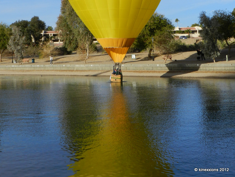
One of the “big” things for the pilots of the balloons was for them to display a bit of expertise and skill by “dipping” their basket into the water and skimming along the surface for a short distance.


Success! Touchdown and liftoff.


More coming my way!


I never realized that the pilots had so much control over their balloons. Of course, the air was still, with hardly a breeze blowing.


Some of the balloons came pretty darn close to the London Bridge!


Just as I snapped this picture, the seagull came into the frame. I think it adds something to the picture – just not sure what! LOL.


Passing directly overhead...

Wednesday, January 18, 2012

What a Way to End the Day!


Sunday, January 15th – A heavy blanket of gray clouds covered the western Arizona sky all day long. As I was returning to the campground the sun appeared beneath the layer of clouds and quickly dropped behind the mountain range. While driving, I was watching the sky change dramatically - all of a sudden it was as if the sky was on fire! There was no safe place to pull off the road but luckily there was a “scenic view” area a short distance away. I was afraid I would miss the photo op but Mother Nature was good to me, this time!

The “normal” view of the camera just wasn't giving me what I wanted. I was able to get off one panoramic shot before the scene changed completely. This photo has been cropped to about half of that panoramic image, and you just “have” to double-click on it to view the bigger picture! Really.

Tuesday, January 17, 2012

Travel Update, etc.

Since leaving Louisiana two weeks ago, Mother Nature has been reasonably good to me. All through Texas, across New Mexico and into Arizona the daytime temperatures were in the low 60s. But the nights were just a bit chilly – in the upper 20s and low 30s. For the most part I stayed in campgrounds that had electricity so I kept warm with the aid of a small electric heater. But still, getting up in the mornings with those low temperatures is not a lot of fun!

So I did some checking of the weather and took a look at the map and have found a spot that is quite comfortable – at least it has been for the past few days! Temperatures have been in the 70s during the day and only dropping into the low 40s at night. I'm not going to say exactly where I'm staying, just that it is in western Arizona – and, no Carol, it's not Quartzsite!

After thinking it over a bit, I've decided to stay here until the end of January when I'll head north to Salt Lake City for RootsTech. I'd like to do some more research while I'm there so I'll be taking this time to review the documents and information obtained last year on my two visits there. I will also be taking a look at my database to try and select which ancestors to research and devise a plan for them.

In addition to that, I have begun (just barely) the boring and tedious but absolutely necessary task of re-organizing my digital files! With everything that I acquired last year and all of the genealogy stuff I had scanned (and never got around to properly naming) prior to leaving on this journey, my digital genealogy files are a really big mess. I can't easily find documents I'm looking for and several, that I know I have, still haven't been found! Anyway, that project is still in its infancy. I'm working with several smaller surname folders to devise a file naming scheme that makes sense to me... more on that later!

In conjunction with renaming files, an even bigger and more complex project on the horizon is to go through and view every document and file – just to see exactly what it is and to ensure that the information and source has been entered into my Legacy database. I know there are a lot of things that have never been entered... Heck, I may even (finally) get around to “attaching” those documents to the appropriate people in the database! But first, before doing that, I need to ensure that the file structures and names are the way I want really want them.

Maybe then, I'll know what I do have! And, just as important if not moreso, where it is located.

One of my favorite quotes regarding genealogy is from fellow Joslin researcher, Dr. Donna Ihns - “When I get to thinking genealogically, I feel like Yul Brynner in 'The King & I': There are times I think I am not sure of what I absolutely know."

Wednesday, January 11, 2012

Arizona Sunset

I hesitated to post two sunset pictures in a row, but you take what Mother Nature gives you – the good along with the bad...


Benson, Arizona.
Sunday, January 8th 2012.

Thursday, December 08, 2011

Change of Venue

After leaving Picacho Peak State Park, I stopped in Tucson long enough to use the wifi and check weather reports. It really didn't look good anywhere. It seems that those winds that blew in from California and wreaked havoc in many places also changed weather patterns. There has been a cold spell in southern Arizona the past few days. I checked weather in southern New Mexico and it didn't look much better.

So, I headed toward a place where I've stayed several times. In hindsight it probably wasn't the best of decisions. But it is what it is.

On Saturday, December 3rd, I arrived at Kartchner Cavern State Park (south of Benson, about 10 miles from I-10) and decided to spend the weekend, knowing that the temperatures were going to be cool. At the time I just didn't realize how cold it was going to get! For the next three days the daytime temperature did not get much above 40 degrees and during the night it dropped into the mid 20s.

Actually, I was quite comfortable as long as I stayed in the van! Since being on the road for so long, I've learned a few things – like how to run a heavy-duty extension cord through the window so that no outside air enters... It's quite cozy in the van with a little heater on. So in spite of the cold weather I enjoyed my stay here. It's a great little park. I didn't take advantage of the nice trails but did take several short walks daily to help keep the blood circulating ;-)


This was the view from my campsite at about 8:15 on Monday morning when the temperature was about 28 degrees! I thought that the clouds might be clearing, but Mother Nature had other ideas.


Less than 15 minutes later the dark clouds rolled in. We even had snow flurries for a short time Monday afternoon.

Tuesday, December 6th - - I've left Kartchner Cavern State Park and am making my way further east. I'll be taking my time, and a meandering route, through New Mexico and Texas to northeast Louisiana to spend the Christmas and New Years Holidays with my friends (who are also distant Joslin cousins). It will be nice to spend the Holidays in the company of family and friends.

Below is the temperature map for the time this post was actually written... looks rather chilly everywhere in the U.S. except the southern-coastal areas!! Yuck.


One advantage of staying in one place for a few days is that I was able to get some genealogy posts written and scheduled. So for the next few days that is what you will see here at kinexxions...

Tuesday, December 06, 2011

Greetings from Arizona!

Thursday, December 1st - - The drive through Las Vegas was mostly uneventful. There was some rain and considerable wind, with gusts up to 40 mph. I'm not a fan of Las Vegas so had no intentions of spending time there. I really just wanted to get south to where I thought it would be warmer. But you know Mother Nature! Always changing things... I spent the night at Cattail Cove State Park south of Lake Havasu City, Arizona. The winds had dropped considerably and the sun was trying to come out from behind the heavy layer of clouds. It was rather cool but at least it wasn't raining!

Friday, December 2nd - - It seems that the winds that came through on Wednesday night also brought cooler temperatures with them. Daytime highs hadn't made it into the 50s and the lows were well into the 30s. A check of the weather on the internet for several places indicated that it was about the same all over southern Arizona. So much for finding a warm place to stay!

I continued south and stopped at Picacho Peak State Park for the night. I had been there at least twice before in my travels through Arizona and knew that it was a nice spot. They had made improvements to the campgrounds and all sites now had electricity. I arrived just before sunset and the clouds had broken up a bit so I decided to go for a walk with camera in hand. And I'm glad that I did!


Monday, June 28, 2010

Horseshoe Bend

A mile or so south of Page, Arizona the Colorado River navigates around a horseshoe bend. There is a 3/4 mile trek through the sand, up and down a hill, to get to the overlook, but it is well worth the effort. I went there twice.

The first visit was late in the evening before the sun set. The overlook faces west so the sun was directly behind the bend.

The river and the rocks, highlighted by the lowering sun.

The early morning light gives it a completely different look.

As the kayaks and canoes were preparing to leave a beach on the bend a big motorboat passed by.

These photos were taken on June 3rd and June 4th. I left Page on the morning of the 4th for Southern California to visit my cousin and to attend the Genealogy Jamboree. After Jamboree I spent two days on the coast near Point Mugu and Ventura (no photos, gloomy, foggy, but still nice) then ventured into the central part of the state...