Sunday, October 04, 2015

The Olympic Peninsula :: Rialto Beach - August 12th

Returning to U.S. 101 after visiting Neah Bay and Cape Flattery, I continued south a short distance to Forks, apparently one of the "sites" of the "Twilight" movie - there were several billboards advertising "Twilight" Tours. I turned onto highway 110 to go to Mora Campground, which is in a portion of the coast that is part of Olympic National Park.

The campground was nearly full so I couldn't be too picky but I drove through three of the five loops of the campground (100+ sites total) before finding an open site that was relatively level.  Then I headed on down to Rialto Beach, about two miles from the campground. It was 3 p.m. and it was cold, damp, and blustery on the beach. I stayed for an hour or so then returned to the campground for a late lunch/early supper. By that time the campground was full.


At about 5:30 p.m. I went back to the beach. The wind had calmed down and it was quite pleasant walking along the shore.


I didn't stick around for the sunset, it was still rather misty and I was tired... However, if you want your sunset "fix" I stayed at Mora Campground in September 2010 when there was a beautiful sunset at Rialto Beach!

The next morning I had the beach practically all to myself for about an hour and a half. The tide was out and I walked all the way over to the "islands" on hard-packed sand.  The sun had not yet made its way over the tree tops and the misty fog gave the place a rather strange, eery, yet interesting feel. About 8 o'clock I headed back to Forks and highway 101, southward bound.

Published under a Creative Commons License.
Becky Wiseman, "The Olympic Peninsula :: Rialto Beach - August 12th," Kinexxions, posted October 4, 2015 (http://kinexxions.blogspot.com/2015/09/the-olympic-peninsula-rialto-beach.html : accessed [access date])

Friday, October 02, 2015

The Olympic Peninsula :: Cape Flattery Trail - August 12th

Returning to U.S. 101 after leaving the site of the Glines Dam, I continued west to Sappho, where I turned north onto highway 113, whith connects to highway 112, which goes along the coastline of the Strait of Juan de Fuca.

Highway 112 was a really fun route to drive with numerous curves and hills to go over and around. And the views weren't bad either. At the end of the route 112 is Neah Bay, the primary community of the Makah Indian Nation and a spur road that takes you about six miles up to the Cape Flattery Trailhead. A Makah Recreation Pass ($10) is required to park at the trail head and can be purchased at several businesses in Neah Bay.

Only 3/4 of a mile in length, the trail consists of boardwalks, dirt paths lined with tree roots, and numerous steps going through a forest to get down to the northwesternmost point of the continental United States. Oh, and there is an elevation loss of 200 feet. Photos of the trail (a good excuse for taking numerous rest breaks) were taken on the way back up to the trailhead.


At the viewing platform a family was taking a group photo.


Almost back to the trailhead.

Published under a Creative Commons License.
Becky Wiseman, "The Olympic Peninsula :: Cape Flattery Trail - August 12th," Kinexxions, posted October 2, 2015 (http://kinexxions.blogspot.com/2015/10/the-olympic-peninsula-cape-flattery.html : accessed [access date])

Wednesday, September 30, 2015

The Olympic Peninsula :: Freeing the Elwha - August 12th

Olympic National Park comprises a rather large area of wilderness, much of which is inacessible to the average person. On the northeast side is the visitor center, the campground, and Hurricane Ridge. U.S. 101 passes through the northwest tip with several short roads going into the park, and then on the western side is the Hoh Rain Forest visitor center and campground. There are also long, narrow strips of the park along the Washington coast with portions accessible along U.S. 101.

One of the short roads off of U.S. 101 on the north side of the park, west of Port Angeles, winds its way along the Elwha River and up to the Glines Canyon Dam.

My first visit to Lake Mills and the Glines Dam on the Elwha River was on September 10, 2010. At that time the water was gradually being released  to lower the lake level in preparation for the removal of the dam. The Elwha Dam, further downstream, was also slated for removal. I was curious to see what the area looked like after the dam had been removed.

Lake Mills was created by Glines Dam in the early 1900s - photo taken September 10, 2010

The Elwha River now runs through the site of the former Lake Mills.

The Glines Dam and Lake Mills - photo taken September 10, 2010.

Actual removal of the dam began on September 15, 2011 with an excavator sitting on a barge in the lake. Explosives were used when the canyon became too narrow for the barge and the last 30 feet of the dam were removed by a blast on August 26, 2014. A large crane had been used throughout the process to transport the concrete debris, which was then hauled away. To save money, parts of the dam that did not block the river were left in place.

The Elwha River, now running free, looking downsteam from the site of the dam.

Published under a Creative Commons License.
Becky Wiseman, "The Olympic Peninsula :: Freeing the Elwha - August 12th," Kinexxions, posted September 30, 2015 (http://kinexxions.blogspot.com/2015/09/the-olympic-peninsula-freeing-elwha.html : accessed [access date])

Tuesday, September 29, 2015

Iron Creek to the Olympic Peninsula - August 9th to 11th

Sunday morning (August 9th) I departed Iron Creek campground. I really wanted to stay longer but felt the need to get the windshield replaced. On the way to Interstate 5, I stopped at the Salkum public library. Like the library in Packwood, the library in Salkum is a public wifi hot spot available when they are closed. Both had good wifi even in the parking lot. I did a search for windshield repair in Olympia and came up with several, selecting the one that I thought would be easiest to get to.

After writing down the address and directions, I headed for Olympia. According to the map, Millersylvania State Park was on route 121 about 5 miles off of I-5 and about 15 miles from Olympia. I arrived there mid-afternoon and had a nice, relaxing stay.

Monday morning (August 10th), I left the campground about 8:30 a.m. and arrived at Auto Glass Professionals  within half an hour. Yes, the windshield would have to be replaced. Yes, they could do it today but not until 1 o'clock and it would take 2 1/2 hours.  Fine with me, I was just glad to be able to get it done so quickly.

I had some "chores" that needed to be done anyway. Grocery shopping. Laundry. While I was doing laundry, the van was facing south again, and that third "tendrill" extended about two more inches down the windshield then turned a couple of inches toward the drivers side. Simply amazing. I went across the street to a restaurant for lunch then went back to the repair shop at about 12:15, a little early but I didn't have anywhere else to go.

The repair was completed by 3 pm, a little ahead of the promised time. I was very happy to be able to leave the city before the evening rush hour. I found my way over to U.S. 101 and drove north for several hours before stopping at Dosewallips State Park near the town of Brinnon.

Tuesday morning (August 11th) I made my way toward Olympic National Park arriving in early afternoon at a campground just inside the main entrance (Hear O' the Hills). After getting a site for the nite I drove up to Hurricane Ridge. It's about a 30 minute drive, uphill, with a lot of curves. Terrific views but there was quite a bit of haze from a fire in the back-country though you couldn't smell the smoke. It's rather unusual to have a fire in a rain forest but the entire Pacific Northwest had an extremely dry summer as have many (most, all) of the western states. This fire was started by lightning the end of May.

I didn't take any pictures during these 3 days... but more to come in future posts!

Published under a Creative Commons License.
Becky Wiseman, "Iron Creek to the Olympic Peninsula - August 9th to 11th," Kinexxions, posted September 29, 2015 (http://kinexxions.blogspot.com/2015/09/iron-creek-to-olympic-peninsula.html : accessed [access date])

Monday, September 28, 2015

Iron Creek Campground - August 5th to 9th

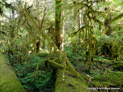
In previous posts, I've mentioned how nice Iron Creek Campground was but never said why. It's been more than a month now since I left and I still miss the place. What made it so special wasn't the big sites or the privacy within the sites or the fact that the sites were not close together or the very nice camp hosts. Sure, all of that was nice! But what really made it special was its location. It was situated in an old growth forest, alongside a river, and had a 2 1/2 mile loop trail that went around the campground. It was, quite simply, beautiful. It is one of the best campgrounds in which I have ever stayed. Ever. And one of my all-time favorite places.

My campsite at Iron Creek Campground.

There is nothing in the picture to provide scale as to the size of the tree and its stump but take my word for it, it was huge!

The only thing available to provide scale was myself. I am 5' 6" tall and I tried to hold the camera straight out so there wouldn't be any distortion. I'd say the tree was at least 5 feet in diameter.

Take another look at that second photo. Lying on the ground behind the stump is another fallen tree, shown above.  You can't see the end of it... I paced it off as best I could and counted 80 paces. At 2 1/2 feet per pace it would be about 200 feet long/tall. And it was just as wide as the other tree.

Moss hung off of the tree limbs and a small fern-like plant grew on the downed trees. It was as soft as down feathers.

On the southern side, along the river (which also ran on the eastern side), there was a wide variety of vegetation.

The golden rays of the setting sun drastically altered the appearance of the forest.


On portions of the trail it was like walking on soft sponges.

Dead and decaying tree stumps become home for new shrubs.

The five nights and four days I was there were, in some respects, magical. The atmosphere of the forest varied with the changing light and weather and depended upon whether you were on the river side or not.  Every morning and every evening I would walk along a portion of the trail, several times doing the entire loop. It was wonderful.

Published under a Creative Commons License.
Becky Wiseman, "Iron Creek Campground - August 5th to 9th," Kinexxions, posted September 28, 2015 (http://kinexxions.blogspot.com/2015/09/iron-creek-campground-august-5th-to-9th.html : accessed [access date])

Saturday, September 26, 2015

Mount Rainier : Grove of the Patriarchs - August 8th

Each time I had come into Mount Rainier National Park, the parking lot for the "Grove of the Patriarchs," near the Stevens Canyon entrance on highway 123, was always full. But I arrived before 9 a.m. this morning and easily found a space to park.

Probably one of the easiest hikes in the park, the one-mile long trail takes you through an old growth forest, over a short suspension bridge, and onto an island in the middle of the Ohanapecosh River.

A short distance along the trail I came across this family "holding up" the tree. I offered to take a picture including the lady with the camera, but she said "No. We take this picture every year with the people in the same position!" What a fun thing to do, I thought.

I walked along the trail for a while with this lady and the lady she was with. They were from Nebraska on their way to visit friends in Tacoma.

This little girl was waiting for the rest of her family. She had been running around on the trail and apparently got tired. She gives some dimension to the size of the roots of the fallen tree.

An "artistic" rendering of someone crossing the river on the suspension bridge. The lighting was perfect for an instant!

I stopped at Box Canyon again. When I was here a couple of days ago the river was in deep shadow and barely visible. Here, on the south side of the bridge, it is 180 feet down to the river.

While on the north side, it is only 115 feet to the river.

At "The Bench" viewpoint after passing through Stevens Canyon. I sat here for over an hour just watching the clouds pass by, sometimes hiding the mountain, as above, other times exposing bits and pieces. And the cars. It was surprising to me how few of them stopped. And how few of the people in those cars actually got out of them when they did stop! The thing is, coming in from the east you don't even see Mount Rainier. And after going around the curve in the middle of the photo you don't see it either, unless you happen to glance in your rear view mirror at just the right time!  It was an interesting spot. Enjoyable sitting in the sunshine but quite cool when the wind picked up.

In the post "Travel Update... Glacier National Park" I mentioned that the windshield, on the passenger side, had been chipped driving through a construction zone in Iowa. One of the tendrils had been slowly migrating toward the rear view mirror. Upon leaving and heading back to the campground I noticed that tendril had lengthened to just beyond the rear view mirror into the drivers side. It now extended over halfway across the windshield. Earlier in the day it had only been about 8 inches long. And two of the other 6 or 8 small tendrils had also begun to lengthen, just while I was at the overlook. One was moving up to the top of the windshield and the other down toward the bottom. I'm guessing it was because Van Dora was facing south and the heat from the sun caused them to begin migrating. I couldn't feel any of the cracks, inside or out, but decided it was probably time to get the windshield replaced.

Published under a Creative Commons License.
Becky Wiseman, "Mount Rainier : Grove of the Patriarchs - August 8th," Kinexxions, posted September 26, 2015 (http://kinexxions.blogspot.com/2015/09/mount-rainier-grove-of-patriarchs.html : accessed [access date])

Thursday, September 24, 2015

Lava Canyon Trail - August 7th

After leaving Ape Cave I continued on up the road to Lava Canyon, my last major stop in the south side area of Mount St. Helens.

This sign, at the beginning of the Lava Canyon Trail, was almost enough to stop me from going but not quite. It warns of high cliffs near the trail along with smooth, slippery rocks. It states "The wisest decision you make here will be to stay on the trails and hike with great caution. Hikers have died in Lava Canyon because they went off-trail." Hmm. Okay. I proceeded. With extreme caution!

A description of the trail states "There are three sections of the Lava Canyon Trail distinguished by increasing difficulty. The upper trail is accessible and paved to a waterfall viewpoint. This portion is the easiest and leads you past a series of interpretive signs, which describe the formation of the canyon."

Looking down into the canyon from just beyond the end of the paved trail.

"Below the waterfall viewpoint the trail becomes more difficult; it is no longer paved and skirts high cliffs. This segment forms a loop, crossing the canyon on a 125-foot cable suspension bridge. The bridge provides spectacular views of the canyon below but may be unnerving to some hikers. The trail returns on the south side of the canyon, crossing a steel bridge upstream of the waterfalls and rejoins the paved trail." (The steel bridge can be seen in the photo above, just behind the lava rock.)

A little further down the trail, which was rather steep at this point and over slick rock with a bit of loose gravel thrown in for good measure. You actually lose sight of the river for awhile and then there was this...


The 125-foot cable suspension bridge. You can hear the river and see portions of it upstream but it is not really visible as you step onto the bridge. I was extremely happy that there was no one else nearby. It knew it would be quite bouncy with just me on it, I really didn't want anyone else crossing it at the same time.

With the camera draped around my neck and both hands on the side rails, I gingerly stepped onto the bridge. It swayed just a little with each step. Or was that just my imagination?

I tried not to look down but as I approached the middle of the bridge I couldn't help myself. I froze for a few seconds and couldn't move. The bridge was gently swaying in the breeze. Not much, but you could definitely feel it. All I could hear was the sound of the water beneath me and the rapid beating of my heart. Then common sense kicked in and I moved quickly off the bridge! Yes, I was shaking when I got to the other side. I sat for a few minutes, looking at the beauty around me and calming my nerves.

Then I went back out onto the bridge, oddly, feeling calm. I just had to get a couple of pictures!

Looking upsteam from (not quite) the middle of the bridge.

Looking down through the wooden slats.

A close-up view of a portion of the river, from the suspension bridge.

It was at this point that the lower trail, the most difficult, descends steeply into the canyon. You are warned "If you are uncomfortable with heights, this segment is not for you. Beginning at the suspension bridge, the trail crosses an exposed cliff face followed by a water crossing with a cable grab-line. A 30-foot metal ladder descends a vertical cliff providing access to the canyons deepest recesses and roaring waterfalls." Um, no. I'd had enough "excitement" for the day. They also recommended that you have a vehicle waiting at the bottom of the trail...

Back on solid ground once again, I continued on up the loop trail. A little more slick rock. More loose gravel. An uphill climb. Really not all that tough.

This view, from near the top, shows the river as it is about to drop over the edge.

The steel bridge. Crossing it was piece of cake after going over the suspension bridge!

The view from the middle of the steel bridge, looking toward the east.

The trail returned to the paved path and it was a short walk back up to the van.  I was on the trail for about an hour and 15 minutes. It was so worth the effort! It was a beautiful day with magnificent scenery.

On the way back down to Forest Road 25, I made one more brief stop. Shown above is the area of the lahar from the 1980 eruption. A lahar is basically a river of mud and water with the consistency of concrete. When Mount St. Helens erupted on the north side the heat melted the snow and ice and sent a huge flow down the south side, carrying with it boulders and downed trees.

The website of The Mount St. Helens Learning and Science Center is a wonderful resource with lots of photos and information on the eruption.

Another picture of Mount St. Helens from the south.

Published under a Creative Commons License.
Becky Wiseman, "Lava Canyon Trail - August 7th," Kinexxions, posted September 25, 2015 (http://kinexxions.blogspot.com/2015/09/lava-canyon-trail-august-7th.html : accessed [access date])