Thursday, September 20th - - Another very nice day was coming to an end. I was driving around Campobello Island looking for a good spot from which to view the sunset. The weather had been as close to perfect as you can get for this time of year and clouds had developed in the western sky, foretelling of the rain that was forecast for tomorrow.
Do you see that streak of color on the left? I had seen something like that a few days before but had not been in a place where I could stop to photograph it. Today I was able to pull safely off the side of the road... It wasn't a rainbow since it wasn't raining and it certainly wasn't in the shape of a traditional rainbow. The streak of color remained in the sky for about 10 minutes then gradually faded away.
And the sunset? Oh, yes. It was magnificent. As an old man I spoke with the next morning put it "The sky just went ballistic!" He was so right. And the photos don't really do it justice.
I couldn't resist taking a panoramic shot, which included the moon (that little white streak in the upper left-hand corner). You're gonna have to double-click the image to view a larger version.
I moved to a location a little further along the road for a slightly different viewpoint. A few minutes later the color had disappeared from the sky.
My one day on Campobello Island was
almost over. The next day (Friday, September 21st) I would travel
west, back to Belfast, where I would spend 3 days with my cousin
Anita (my dad and her mother were brother and sister) and her husband
Tom. We got caught up on everything since my
previous visit 3 years ago. We talked about so many things during
our time together, reminiscing about our younger days and discussing
various family members (both living and dead). Yes, it was a very
good visit. Thank you, Tom and Anita! I treasure the time we had
together.
Showing posts with label Canada. Show all posts
Wednesday, October 10, 2012
Campobello Island :: Sunset
Labels:
Campobello,
Canada,
Journey-2012-Resumed,
New Brunswick
Tuesday, October 09, 2012
Campobello Island :: Mulholland Point and Seals in the Narrows
Thursday, September 20th - - In 1958 the governments of Canada and the United States entered into an agreement to construct a bridge across the Lubec Narrows to provide easy access to and from Campobello Island.
There is a small park at Mulholland Point, which includes the Mulholland Lighthouse. Several signposts provide information about the bridge, the lighthouse, and give a brief history of the town of Lubec, Maine.
But what fascinated me, not visible in that first photo, was the high waves caused by the out-going tide. And then, there were those little black specks in the water, which upon closer examination with the help of the zoom lens, turned out to be seals!
I happened to arrive just as the tide was starting to go out. The water was moving very fast out in the middle of the narrows where the waves were the highest.
The larger seals would fight their way up the current and then rapidly float back downstream. They were certainly having fun, and I was certainly enjoying watching them.
There were probably about 25-30 seals in the group. I'm guessing that it must have been a good feeding area. The seagulls were flying all around also dipping in and out of the water.
The seals were continually diving and disappearing into the water, resurfacing some distance away from where they went under.
The next morning on my return to the United States, I stopped to get a shot of the Mulholland Lighthouse and the town of Lubec, Maine on the other side of the narrows. Even though the tide was low and not moving rapidly, there were seals floating in the water. I even saw an eagle flying amongst the seagulls.
The Roosevelt Memorial Bridge was opened for operation in 1962. A portion of Campobello Island can be seen on the left while the town of Lubec, Maine is on the right. Taken from Mulholland Point.
But what fascinated me, not visible in that first photo, was the high waves caused by the out-going tide. And then, there were those little black specks in the water, which upon closer examination with the help of the zoom lens, turned out to be seals!
I happened to arrive just as the tide was starting to go out. The water was moving very fast out in the middle of the narrows where the waves were the highest.
The larger seals would fight their way up the current and then rapidly float back downstream. They were certainly having fun, and I was certainly enjoying watching them.
There were probably about 25-30 seals in the group. I'm guessing that it must have been a good feeding area. The seagulls were flying all around also dipping in and out of the water.
The seals were continually diving and disappearing into the water, resurfacing some distance away from where they went under.
The next morning on my return to the United States, I stopped to get a shot of the Mulholland Lighthouse and the town of Lubec, Maine on the other side of the narrows. Even though the tide was low and not moving rapidly, there were seals floating in the water. I even saw an eagle flying amongst the seagulls.
Labels:
Campobello,
Canada,
Journey-2012-Resumed,
New Brunswick
Monday, October 08, 2012
Campobello Island :: Head Harbour Lightstation
Thursday, September 20th - - Also known as the East Quoddy Head Lighthouse, the Head Harbour Lightstation sits on a small island at the northeastern tip of Campobello Island. Built in 1829, it is the oldest surviving lighthouse in New Brunswick and one of the oldest in Canada. Its distinguishing feature is the red St. George Cross on the front.
However, at low tide, this island is no longer an island. I arrived at Campobello too late to take advantage of the low tide and visit the station. Ladders, partially visible in the second photo, allow visitors access to go down and walk across the bay.
The first three photos were taken between 12:45 and 1:30 while the last three were taken between 5:30 and 5:45 (Eastern Time, in reality though they were an hour later because Campobello Island is in the Atlantic Time Zone).
However, at low tide, this island is no longer an island. I arrived at Campobello too late to take advantage of the low tide and visit the station. Ladders, partially visible in the second photo, allow visitors access to go down and walk across the bay.
The first three photos were taken between 12:45 and 1:30 while the last three were taken between 5:30 and 5:45 (Eastern Time, in reality though they were an hour later because Campobello Island is in the Atlantic Time Zone).
Labels:
Campobello,
Canada,
Journey-2012-Resumed,
New Brunswick
Sunday, October 07, 2012
Campobello Island :: The Roosevelt Cottage
Thursday, September 20th - - The Roosevelt Campobello International Park was created in 1964 as a memorial to Franklin Delano Roosevelt who spent summers on Campobello Island from the time he was a year old in 1883 until he was stricken with polio in 1921. FDR last visited Campobello in 1939 but Eleanor and the children returned often, through the early 1960s.
The visitor center has a 15-minute film about the Roosevelt's and Campobello Island as well as several exhibit areas. All are worth spending the time to view.
This little fenced-in area was identified as the "Best Photo Area" and I would imagine just about every visitor to the FDR cottage has taken a photo from this spot... including me.
I did not take any photos of the interior. There are 34 rooms furnished with ordinary, every-day items that were used by the Roosevelt family. Nothing ostentatious or fancy, rather more of a practical and utilitarian nature with an emphasis on comfort and simplicity. That, in itself, was impressive. The rooms have been restored with their original furnishings though the wallpapers are reproductions. The tour of the home is self-guided with docents available to answer questions about the house, its furnishings, and the family.
Later in the day, I took a drive along the carriage roads. Unlike those built by John D. Rockefeller, Jr. at Acadia National Park, these roads can be used by motorized vehicles.
According to one of the brochures, very little of the forest cover from the Roosevelt era has survived in the 2800 acre park. Apparently, the interim owners (after the Roosevelt family sold the land and before the park was established) logged the island for pulpwood. The area has been allowed to regenerate. I saw very few large trees on my drive through the forests.
The Herring Cove Provincial Park borders the Roosevelt Campobello International Park. We stayed at the Herring Cove Campground, which was quite nice and reasonably priced. The two parks take up roughly the first third to almost half of Campobello Island. The rest of the island is privately owned by the 1100 or so residents.
The view of the FDR cottage from the visitor center.
The visitor center has a 15-minute film about the Roosevelt's and Campobello Island as well as several exhibit areas. All are worth spending the time to view.
This little fenced-in area was identified as the "Best Photo Area" and I would imagine just about every visitor to the FDR cottage has taken a photo from this spot... including me.
It does make for a pretty picture, doesn't it?
I did not take any photos of the interior. There are 34 rooms furnished with ordinary, every-day items that were used by the Roosevelt family. Nothing ostentatious or fancy, rather more of a practical and utilitarian nature with an emphasis on comfort and simplicity. That, in itself, was impressive. The rooms have been restored with their original furnishings though the wallpapers are reproductions. The tour of the home is self-guided with docents available to answer questions about the house, its furnishings, and the family.
Later in the day, I took a drive along the carriage roads. Unlike those built by John D. Rockefeller, Jr. at Acadia National Park, these roads can be used by motorized vehicles.
According to one of the brochures, very little of the forest cover from the Roosevelt era has survived in the 2800 acre park. Apparently, the interim owners (after the Roosevelt family sold the land and before the park was established) logged the island for pulpwood. The area has been allowed to regenerate. I saw very few large trees on my drive through the forests.
The Herring Cove Provincial Park borders the Roosevelt Campobello International Park. We stayed at the Herring Cove Campground, which was quite nice and reasonably priced. The two parks take up roughly the first third to almost half of Campobello Island. The rest of the island is privately owned by the 1100 or so residents.
Labels:
Campobello,
Canada,
Journey-2012-Resumed,
New Brunswick
Friday, September 10, 2010
Moving On :: Back in the Lower 48
Wednesday, September 1st - - It was cool this morning when I woke up but there was sunshine and blue skies overhead, for which I was very thankful. After finding free wifi (at a Safeway grocery store!) in Smithers and spending an hour uploading and scheduling blog posts, it was almost eleven o'clock before I was on my way once again.
Yesterday I had gotten to the end of the Cassiar Highway and turned east onto the Yellowhead Highway (Route 16). The last two hours on the Cassiar I saw perhaps two dozen vehicles. That number was surpassed in two minutes on the Yellowhead. It was as though I had turned the corner and gone into a whole different world. Not only was there more traffic, but the landscape was different too. There were still mountains and forests but there were also open areas of pasture and farmland. Houses, and buildings, and utility poles lined the highway for miles. Towns! And traffic! Civilization? Instead of watching out for bears and moose and other four legged critters I had to watch out for other drivers.
I continued east on the Yellowhead Highway to Prince George where I turned south on the Cariboo Highway (Route 97). There was road construction on the Cariboo, which caused some delay but it wasn't too bad although traffic was backed up for quite a ways. In one section they had completely torn up the road bed and it was a big mess. Concentrating on getting through that area I caught a glimpse of something walking along the side of the highway. I couldn't hardly believe my eyes – it was a black bear! And a pretty good-sized one too. There were no construction workers nearby so no one was in any immediate danger but still, it was there amongst all the noise and traffic, out in the open, and I could see it in my rear-view mirror as I drove on.
A short time later I stopped at the Canyon Creek Campground and RV Park in Hixon, about 35 miles south of Prince George. It had been a short driving day, only 265 miles. And it was only 410 miles more to the U.S. Border.
I would be remiss in not mentioning the fact that today - September 1, 2010 - marks the beginning of the second year of this incredible journey. One year ago I embarked upon an odyssey that has taken me places I had only dreamed of and some places that I had never heard of...
==========
Thursday, September 2nd - - It was another chilly morning. Cloudy but no rain. Continued heading south on the Cariboo Highway to Cache Creek where I turned west onto Trans-Canada Highway 1. By the time I got to Cache Creek at two o'clock the temperature had risen to 74 degrees – the warmest temperature I'd seen in three weeks! And it felt good. At 4:30, even though I was only about 60 miles from the U.S. border, I stopped for the night at the Telte-Yet Campground in Hope, British Columbia - it was 77 in the shade! Awesome. After paying for the campsite, I had $10 in Canadian currency left and figured this would be my last night in Canada, so I walked across the steet to Dairy Queen and had a banana split to commemorate the occasion!
==========
Friday, September 3rd - - Sunny skies once again. Left Hope at 9:30 this morning and got to the Sumas, Washington border crossing at 10:45 along with lots of other vehicles. I lucked out and got into a fast-moving lane - it only took twenty minutes to get through. There was no fancy sign, like in Alaska, welcoming me back – just this electronic billboard flashing its message...

Yesterday I had gotten to the end of the Cassiar Highway and turned east onto the Yellowhead Highway (Route 16). The last two hours on the Cassiar I saw perhaps two dozen vehicles. That number was surpassed in two minutes on the Yellowhead. It was as though I had turned the corner and gone into a whole different world. Not only was there more traffic, but the landscape was different too. There were still mountains and forests but there were also open areas of pasture and farmland. Houses, and buildings, and utility poles lined the highway for miles. Towns! And traffic! Civilization? Instead of watching out for bears and moose and other four legged critters I had to watch out for other drivers.
I continued east on the Yellowhead Highway to Prince George where I turned south on the Cariboo Highway (Route 97). There was road construction on the Cariboo, which caused some delay but it wasn't too bad although traffic was backed up for quite a ways. In one section they had completely torn up the road bed and it was a big mess. Concentrating on getting through that area I caught a glimpse of something walking along the side of the highway. I couldn't hardly believe my eyes – it was a black bear! And a pretty good-sized one too. There were no construction workers nearby so no one was in any immediate danger but still, it was there amongst all the noise and traffic, out in the open, and I could see it in my rear-view mirror as I drove on.
A short time later I stopped at the Canyon Creek Campground and RV Park in Hixon, about 35 miles south of Prince George. It had been a short driving day, only 265 miles. And it was only 410 miles more to the U.S. Border.
I would be remiss in not mentioning the fact that today - September 1, 2010 - marks the beginning of the second year of this incredible journey. One year ago I embarked upon an odyssey that has taken me places I had only dreamed of and some places that I had never heard of...
==========
Thursday, September 2nd - - It was another chilly morning. Cloudy but no rain. Continued heading south on the Cariboo Highway to Cache Creek where I turned west onto Trans-Canada Highway 1. By the time I got to Cache Creek at two o'clock the temperature had risen to 74 degrees – the warmest temperature I'd seen in three weeks! And it felt good. At 4:30, even though I was only about 60 miles from the U.S. border, I stopped for the night at the Telte-Yet Campground in Hope, British Columbia - it was 77 in the shade! Awesome. After paying for the campsite, I had $10 in Canadian currency left and figured this would be my last night in Canada, so I walked across the steet to Dairy Queen and had a banana split to commemorate the occasion!
==========
Friday, September 3rd - - Sunny skies once again. Left Hope at 9:30 this morning and got to the Sumas, Washington border crossing at 10:45 along with lots of other vehicles. I lucked out and got into a fast-moving lane - it only took twenty minutes to get through. There was no fancy sign, like in Alaska, welcoming me back – just this electronic billboard flashing its message...

I was “home” again, and happy to be here!
Labels:
Alaska,
Canada,
The Journey,
Washington
Thursday, September 09, 2010
Moving On :: A Jog in the Road Back
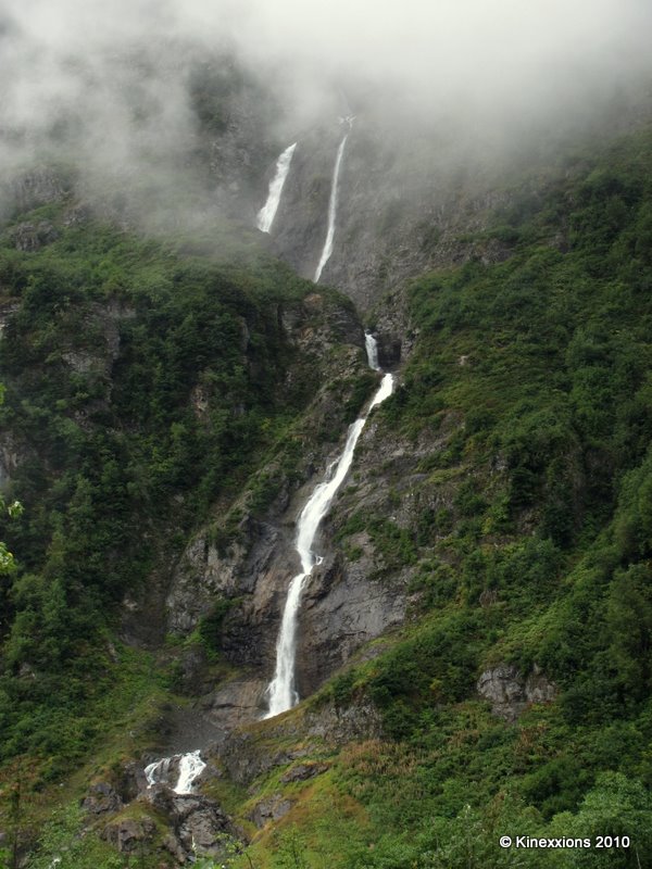
Monday, August 30th - - Highway 37A west from Cassiar Highway (in British Columbia) is also known as Glacier Highway. Though the clouds had moved in and were hovering over the tops of the mountains, portions of a few of the glaciers could be seen from the highway, which began in a wide valley but soon narrowed. A river on the left and the mountains on both sides dominated the views. Numerous waterfalls and streams could be seen cascading down the sides of the mountains. Along with the clouds came the rain, sometimes heavy, and I drove slowly through the valley, savoring its beauty.
One of the streams/waterfalls that drop hundreds of feet down the mountain side along the Glacier Highway.
Halfway to Stewart the valley expanded once more. A first glimpse of Stewart, in the rain and early evening twilight, was not impressive. It looked drab and run-down. I passed by an RV Park and went on to the Municipal Campground, which was in a heavily forested area. It looked dark under the trees even though it was still early evening. But it offered flush toilets and hot showers, so it got the nod for the night!
==========
Tuesday, August 31st - - Stewart didn't look much better when I drove through town this morning. It was drizzling rain and it was foggy. Visualize a small town in America in the 1950s then move forward 60 years but make no changes to the town. Old buildings add character to a place but most of these buildings were way past their prime.
I stopped at the Visitor Center, which appeared to be one of the newest buildings in town, and picked up a self-guiding car-tour map of the road that goes to Hyder, Alaska and which continues on to Salmon Glacier. I was informed by the nice lady that it is a dirt road but once you get through Hyder and beyond the Bear Viewing Platform and get back into British Columbia, the road is well maintained and in good condition. The implication was that the U.S. portion of the road wasn't in good shape. Well, it wasn't implied, she came right out and said that the U.S. portion of the road was terrible! It had potholes and washboard areas and was narrow in spots – but it was only for a couple of miles. It's safe, she said, just take it easy.
Throwing caution to the wind, I drove up that road. Slowly and carefully, taking it easy. I've avoided traveling on dirt/gravel roads as much as possible. I just don't like them. But sometimes you have to risk it and hope that the risks are worth the rewards. They were.
Hyder, Alaska (four miles from downtown Stewart) is a small town of 100 happy souls, and one old grouch. So says a sign on one of the old, rugged buildings. The dirt road, the rain, and the fog didn't add much to the appeal of the place. There were about 20 old buildings (some were in use as small shops) and two RV Parks along with a Post Office and a General Store.
I stopped at the Bear Viewing Platform (about 3 miles from Hyder) that is managed by the National Forest Service. No bears were in sight and none had been seen yet today. The Ranger said a mother with her cubs usually comes in about noon and again about six o'clock. It was only nine so I continued on to Salmon Glacier seventeen miles further up the road.
Six miles from the Bear Viewing Platform, I crossed back into British Columbia. And the road got considerably better, as promised. All this time the road is going up. And it keeps going up as well as winding itself around the side of the mountain. And it is still drizzling rain. Ten miles further there is a turnout and I get my first look at Salmon Glacier. Splendid!
The river of ice fills the valley below and continues on up and around the mountain peak on the left. Those black streaks are dirt and rocks that the glacier has picked up as it moves imperceptibly over the mountains.

Crevasses and holes would make it a rather treacherous journey. These aren't just ripples in the surface, they are deep. Perhaps a hundred feet or more.
Salmon Glacier from another turnout two miles north. The clouds and fog obscured the little bit of sun that occasionally came through.
The Salmon Glacier is the fifth largest glacier in Canada and is a remnant of the last glaciation period which occurred 14,000 years ago. What I saw and what is shown here are but a very small portion of the glacier which extends way back beyond the horizon.
The sun did make an appearance now and then and the rain finally stopped - briefly. Down in the valley and a few miles to the south are the towns of Hyder, Alaska and Stewart, British Columbia.
Even more slowly than going up, I made my way back down the mountain. I stopped at the Bear Viewing Platform for about 45 minutes. Saw a lot of Chum Salmon in the river, both dead and spawning, but no bears. And the sun was, once more, hidden by the clouds.
I returned to Cassiar Highway and the long drive south, stopping at the town of Smithers for the night. And the rain? It seems that it was the first that Stewart/Hyder had seen in two months! And it followed me to Smithers where I learned that they too hadn't had rain for many weeks.
One of the streams/waterfalls that drop hundreds of feet down the mountain side along the Glacier Highway.Halfway to Stewart the valley expanded once more. A first glimpse of Stewart, in the rain and early evening twilight, was not impressive. It looked drab and run-down. I passed by an RV Park and went on to the Municipal Campground, which was in a heavily forested area. It looked dark under the trees even though it was still early evening. But it offered flush toilets and hot showers, so it got the nod for the night!
==========
Tuesday, August 31st - - Stewart didn't look much better when I drove through town this morning. It was drizzling rain and it was foggy. Visualize a small town in America in the 1950s then move forward 60 years but make no changes to the town. Old buildings add character to a place but most of these buildings were way past their prime.
I stopped at the Visitor Center, which appeared to be one of the newest buildings in town, and picked up a self-guiding car-tour map of the road that goes to Hyder, Alaska and which continues on to Salmon Glacier. I was informed by the nice lady that it is a dirt road but once you get through Hyder and beyond the Bear Viewing Platform and get back into British Columbia, the road is well maintained and in good condition. The implication was that the U.S. portion of the road wasn't in good shape. Well, it wasn't implied, she came right out and said that the U.S. portion of the road was terrible! It had potholes and washboard areas and was narrow in spots – but it was only for a couple of miles. It's safe, she said, just take it easy.
Throwing caution to the wind, I drove up that road. Slowly and carefully, taking it easy. I've avoided traveling on dirt/gravel roads as much as possible. I just don't like them. But sometimes you have to risk it and hope that the risks are worth the rewards. They were.
Hyder, Alaska (four miles from downtown Stewart) is a small town of 100 happy souls, and one old grouch. So says a sign on one of the old, rugged buildings. The dirt road, the rain, and the fog didn't add much to the appeal of the place. There were about 20 old buildings (some were in use as small shops) and two RV Parks along with a Post Office and a General Store.
I stopped at the Bear Viewing Platform (about 3 miles from Hyder) that is managed by the National Forest Service. No bears were in sight and none had been seen yet today. The Ranger said a mother with her cubs usually comes in about noon and again about six o'clock. It was only nine so I continued on to Salmon Glacier seventeen miles further up the road.
Six miles from the Bear Viewing Platform, I crossed back into British Columbia. And the road got considerably better, as promised. All this time the road is going up. And it keeps going up as well as winding itself around the side of the mountain. And it is still drizzling rain. Ten miles further there is a turnout and I get my first look at Salmon Glacier. Splendid!
The river of ice fills the valley below and continues on up and around the mountain peak on the left. Those black streaks are dirt and rocks that the glacier has picked up as it moves imperceptibly over the mountains.
It would not be an easy task, if even possible, to hike over this.
Crevasses and holes would make it a rather treacherous journey. These aren't just ripples in the surface, they are deep. Perhaps a hundred feet or more.
Salmon Glacier from another turnout two miles north. The clouds and fog obscured the little bit of sun that occasionally came through.
The Salmon Glacier is the fifth largest glacier in Canada and is a remnant of the last glaciation period which occurred 14,000 years ago. What I saw and what is shown here are but a very small portion of the glacier which extends way back beyond the horizon.
The sun did make an appearance now and then and the rain finally stopped - briefly. Down in the valley and a few miles to the south are the towns of Hyder, Alaska and Stewart, British Columbia.Even more slowly than going up, I made my way back down the mountain. I stopped at the Bear Viewing Platform for about 45 minutes. Saw a lot of Chum Salmon in the river, both dead and spawning, but no bears. And the sun was, once more, hidden by the clouds.
I returned to Cassiar Highway and the long drive south, stopping at the town of Smithers for the night. And the rain? It seems that it was the first that Stewart/Hyder had seen in two months! And it followed me to Smithers where I learned that they too hadn't had rain for many weeks.
Labels:
Alaska,
Canada,
Glaciers,
The Journey
Wednesday, September 08, 2010
Moving On :: The Cassiar Highway
Monday, August 30th - - Cold temperatures with blue skies and sunshine greeted me as I left Watson Lake. It was 33 degrees when I woke up at 6:30 this morning. It had been a clear, dark sky last night and it was the first time I had seen the stars since leaving Montana over a month ago!
I had to backtrack about ten miles to get onto the Cassiar Highway (Route 37) and it wasn't long before I got into a combination of smoke and fog. The smoke was due to the forest fires that started a month or so ago and were still smoldering. The road had been closed to traffic for a couple of weeks.
Early morning sun streaming through the forest. Most of the trees near the road were not affected by the fire but there was a smoky haze and acrid smell that filled the air.
This section was particularly bad because the smoke was “enhanced” by fog from a nearby lake.

There isn't much in the way of “civilization” along the Cassiar Highway. It travels through 450 miles of wilderness, making its way through valleys and over mountains. Not much different than many of the other highways I've traveled thus far here in Canada and Alaska. But this seemed more remote. Perhaps it was my frame of mind or the fact that there were few other vehicles on the highway. Or maybe it was because of the wildlife I saw along the way. A multicolored fox with fur of brown and red and black and with a bushy tail as long as its body. And bears. Eight of them were seen, briefly, individually, in a 100-mile stretch of the highway.
About 350 miles into the drive I was looking for a place to spend the night. There was a road that branched off of Highway 37 and it looked intriguing. It was paved, only 40 miles long, and it went to two towns next to each other – Stewart in British Columbia and Hyder in Alaska. I made the turn at the junction and headed west...

I had to backtrack about ten miles to get onto the Cassiar Highway (Route 37) and it wasn't long before I got into a combination of smoke and fog. The smoke was due to the forest fires that started a month or so ago and were still smoldering. The road had been closed to traffic for a couple of weeks.
Early morning sun streaming through the forest. Most of the trees near the road were not affected by the fire but there was a smoky haze and acrid smell that filled the air.
This section was particularly bad because the smoke was “enhanced” by fog from a nearby lake.
Less than an hour later, I was through the burned-out area and back in sunshine.
There isn't much in the way of “civilization” along the Cassiar Highway. It travels through 450 miles of wilderness, making its way through valleys and over mountains. Not much different than many of the other highways I've traveled thus far here in Canada and Alaska. But this seemed more remote. Perhaps it was my frame of mind or the fact that there were few other vehicles on the highway. Or maybe it was because of the wildlife I saw along the way. A multicolored fox with fur of brown and red and black and with a bushy tail as long as its body. And bears. Eight of them were seen, briefly, individually, in a 100-mile stretch of the highway.
About 350 miles into the drive I was looking for a place to spend the night. There was a road that branched off of Highway 37 and it looked intriguing. It was paved, only 40 miles long, and it went to two towns next to each other – Stewart in British Columbia and Hyder in Alaska. I made the turn at the junction and headed west...

The route from Skagway – north, then east, and finally south.
Labels:
Alaska,
Canada,
The Journey
Tuesday, September 07, 2010
Moving On :: Leaving Alaska
Saturday, August 28th - - My stay in Juneau was at an end. The ferry didn't leave until 3 pm but, since I had a vehicle, I had to check in by one o'clock. There would have been time to take another tour I suppose, but after yesterday's adventure I really didn't see much point in it – I don't think anything could have topped it. For the first time in a long time sleep didn't come easily last night. My mind wouldn't let go of the excitement of the day and I kept reliving the events over and over.
But even with lingering in bed a little longer there was plenty of time to get around in the morning and to run a few errands (stock up on groceries and a few other items and fill up the gas tank). I then found a turnout along the highway and whiled away the remaining bit of time by doing absolutely nothing – sittin' and thinkin' and watchin' the clouds go by... (and more of the same once I got in the queue for the ferry!)
The ferry ride was mostly uneventful, the hours passed by quickly. However, at about five o'clock someone yelled out “Whale on the left.” Fortunately, that just happened to be the side where I was sitting... it was rather far off and moving away from us but we watched that lone humpback whale breach (jump out of the water) five times! It was yet another of those “WOW” moments, for that is all that it lasted, just a few brief moments, but it was a wondrous sight to see.
Clouds filled the sky as we got close to Haines. We docked at 7:30 and then there was a stopover of an hour to let people and vehicles disembark, then it was another hour to Skagway.
Pulling into the ferry dock at Skagway at 9:30 pm. It was interesting to me that the Captain used two spotlights, one on either side of the ferry, to guide it into the docking area. A few minutes later I drove off and into Skagway. For some reason, it surprised me that it was dark already when I got there. And it was warm. Not hot, but much warmer than it had been for many weeks. There were two RV Park[ing lot]s in Skagway but I had noticed some RVs pulling into the ferry terminal parking lot and decided to join them there for the night. If you think about it - with its lighted lot and security patrols - it was as safe (if not safer) as any campground.
=========
Sunday, August 29th - - It was raining lightly when I left the ferry terminal parking lot at eight o'clock. I drove down several streets in the nearly vacant town. Few people were out and about and stores were not yet open. There were, however, three cruise ships in the harbor that had pulled in during the night, filled with people about to fill the town.
Ready to move on, I found the main highway and drove north out of town. Less than an hour later I was out of Alaska and back in Canada. A part of me wanted to return to Alaska to do some of the things that I hadn't done (because of time, money, or the weather – or a combination of all three) but deep down I knew it was time to leave. Perhaps one day I will return. But if I don't, that's okay because I've been there and had some amazing and wonderful experiences that will be with me for a long time to come.
The South Klondike Highway heads north out of Skagway following the Klondike River. On the other side of the river was the White Pass & Yukon Route railway, which was one of the last narrow-gauge railroads built in North America. Began in May 1898, more than 2,000 workers labored with hand tools for 18 months to build the railroad. It claimed 35 lives. The highway that I was driving on was only 30 years old (began in 1978 and dedicated in 1981) and certainly wasn't constructed with hand tools!


The unusual William Moore suspension bridge spans a 110-foot-wide gorge over Moore Creek, which is 180 feet below.


If I hadn't missed the turnoff to Carcross Road I would not have seen beautiful Emerald Lake (also known as Rainbow Lake).
The long and winding road, typical of the Carcross Highway, which goes from the town of Carcross to Watson Lake. The town was originally named Caribou Cross because herds of caribou used to cross there. I guess it is fitting that cars cross through Carcross now.
The first time (on August 3rd) I passed through Watson Lake, home of the Sign Post Forest, crowds (well, maybe not crowds, but more than a few people) filled the streets. Today, I saw two people. You can tell it is getting close to the end of the summer and the end of the tourist season. The streets, and campgrounds in Yukon Territory, are nearly empty.
But even with lingering in bed a little longer there was plenty of time to get around in the morning and to run a few errands (stock up on groceries and a few other items and fill up the gas tank). I then found a turnout along the highway and whiled away the remaining bit of time by doing absolutely nothing – sittin' and thinkin' and watchin' the clouds go by... (and more of the same once I got in the queue for the ferry!)
The ferry ride was mostly uneventful, the hours passed by quickly. However, at about five o'clock someone yelled out “Whale on the left.” Fortunately, that just happened to be the side where I was sitting... it was rather far off and moving away from us but we watched that lone humpback whale breach (jump out of the water) five times! It was yet another of those “WOW” moments, for that is all that it lasted, just a few brief moments, but it was a wondrous sight to see.
Clouds filled the sky as we got close to Haines. We docked at 7:30 and then there was a stopover of an hour to let people and vehicles disembark, then it was another hour to Skagway.
Pulling into the ferry dock at Skagway at 9:30 pm. It was interesting to me that the Captain used two spotlights, one on either side of the ferry, to guide it into the docking area. A few minutes later I drove off and into Skagway. For some reason, it surprised me that it was dark already when I got there. And it was warm. Not hot, but much warmer than it had been for many weeks. There were two RV Park[ing lot]s in Skagway but I had noticed some RVs pulling into the ferry terminal parking lot and decided to join them there for the night. If you think about it - with its lighted lot and security patrols - it was as safe (if not safer) as any campground.=========
Sunday, August 29th - - It was raining lightly when I left the ferry terminal parking lot at eight o'clock. I drove down several streets in the nearly vacant town. Few people were out and about and stores were not yet open. There were, however, three cruise ships in the harbor that had pulled in during the night, filled with people about to fill the town.
Ready to move on, I found the main highway and drove north out of town. Less than an hour later I was out of Alaska and back in Canada. A part of me wanted to return to Alaska to do some of the things that I hadn't done (because of time, money, or the weather – or a combination of all three) but deep down I knew it was time to leave. Perhaps one day I will return. But if I don't, that's okay because I've been there and had some amazing and wonderful experiences that will be with me for a long time to come.
The South Klondike Highway heads north out of Skagway following the Klondike River. On the other side of the river was the White Pass & Yukon Route railway, which was one of the last narrow-gauge railroads built in North America. Began in May 1898, more than 2,000 workers labored with hand tools for 18 months to build the railroad. It claimed 35 lives. The highway that I was driving on was only 30 years old (began in 1978 and dedicated in 1981) and certainly wasn't constructed with hand tools!

A portion of the White Pass & Yukon Route railroad, with train, no less!

The train passing over Pitchfork Falls.
The unusual William Moore suspension bridge spans a 110-foot-wide gorge over Moore Creek, which is 180 feet below.
Natures Rock Garden.

Just north of the U.S. Border is an area referred to as the moonscape.

The trees are small and shaped by the wind and snow.
If I hadn't missed the turnoff to Carcross Road I would not have seen beautiful Emerald Lake (also known as Rainbow Lake).
The long and winding road, typical of the Carcross Highway, which goes from the town of Carcross to Watson Lake. The town was originally named Caribou Cross because herds of caribou used to cross there. I guess it is fitting that cars cross through Carcross now.The first time (on August 3rd) I passed through Watson Lake, home of the Sign Post Forest, crowds (well, maybe not crowds, but more than a few people) filled the streets. Today, I saw two people. You can tell it is getting close to the end of the summer and the end of the tourist season. The streets, and campgrounds in Yukon Territory, are nearly empty.
Labels:
Alaska,
Canada,
The Journey
Saturday, August 28, 2010
Moving On :: Kluane to Haines
Monday, August 23rd - - I continued on the Alaska Highway from Lake Kluane to Haines Junction where I turned south on the Haines Highway. Designated a National Scenic Byway, it is one of the prettiest drives in Alaska (in my opinion). What makes it different from all the other Scenic Byways is that you have scenic views that can actually be seen! They aren't completely hidden by rows of trees alongside the highway. The 150 miles from Haines Junction takes you through a portion of the Yukon Territory, British Columbia, and Alaska.
I didn't take many pictures along the way. Though pretty, the scenery didn't lend itself well to picture taking, and the further south I drove the cloudier it got. So you'll just have to take my word for it that it was beautiful.
There was some road construction and about 15 miles of gravel road, and my van, which had to go through two car washes in Anchorage to get clean, was now dirty again...


It had started raining about 30 miles north of the Alaska border and the rain continued all the way to Haines, 40 miles south of the border. I stayed at the campground at Chilkoot Lake State Recreation Area (which also happens to be where Sue and Fred stayed). It is ten miles east of Haines at the end of the highway.
I didn't take many pictures along the way. Though pretty, the scenery didn't lend itself well to picture taking, and the further south I drove the cloudier it got. So you'll just have to take my word for it that it was beautiful.
There was some road construction and about 15 miles of gravel road, and my van, which had to go through two car washes in Anchorage to get clean, was now dirty again...
There were signs of autumn in the air, besides the chilly weather.


It had started raining about 30 miles north of the Alaska border and the rain continued all the way to Haines, 40 miles south of the border. I stayed at the campground at Chilkoot Lake State Recreation Area (which also happens to be where Sue and Fred stayed). It is ten miles east of Haines at the end of the highway.
Labels:
Alaska,
Canada,
The Journey