Showing posts with label Hovenweep. Show all posts

Monday, September 15, 2014

Where Have I Been?

My apologies. I have not been keeping y'all up to date very well, have I? So far this trip I've had internet access just one day. It's been kind of nice being "disconnected" from the world for a while. I've been keeping to the "back roads" of America and not eating at 'that' fast-food joint...

Today is a prep day and a day of relaxing. Sorting through 'stuff' to make sure everything that will be needed in the next 17 days is at hand and hoping that what I've decided to take will all fit in the 'dry bag' that will be provided. Tomorrow we head up to Lee's Ferry for the night with departure Wednesday morning. Excitement is in the air!

Below are some pictures of the places I've been in the past week.  More to come later...

Great Sand Dunes National Park northeast of Alamosa, Colorado.

Black Canyon of the Gunnison (Colorado).

And there was more than cows on the road... poor Van Dora was in need of a bath after this stretch of highway...

A Ranger pointing out the petroglyphs on a guided tour at Hovenweep National Monument (in Utah, west of Cortez, Colorado).

Early evening in Grand Canyon National Park, Arizona.
~ ~ ~ ~ ~ ~ ~ ~ ~ ~
Note: The page Grand Canyon Raft Trip lists all of my posts published about this Grand Adventure!

Published under a Creative Commons License.
Becky Wiseman, "Where Have I Been?," Kinexxions, posted September 15, 2014 (http://kinexxions.blogspot.com/2014/09/where-have-i-been.html)

Saturday, June 05, 2010

Hovenweep :: The Holly Group

The ruins of the Square Tower Group are the most accessible since they are only a few hundred yards from the Visitors Center. Another site relatively close by (a four mile hike, one way) is the Holly Group, which was named for Jim Holley who ranched and traded in that area during the late 1800s. (Did you notice the spelling variation?)

On the morning after my arrival at Hovenweep, I made the four mile trek to Keeley Canyon to visit the Holly Group. The trail was described as primitive and moderately strenuous. Near the beginning of the trail you had to scramble over some boulders then go through a narrow (I had to go sideways most of the way), seemingly long, passageway between two very, very, large boulders. If you were claustrophobic, you might have a problem! But you could see light at the other end. Once beyond that there was a little more rock scrambling but when you got down to the bottom it was a mostly sandy trail for the next two miles. You did have to go down, through, and up the sides of several dry gulches and there were ladders in several places to get you down/up the steeper places.

It was a quite pleasant walk. The morning started out cool but quickly warmed up. It was quiet, as only nature can be. A light breeze rustled the trees. The birds were chirping and serenading each other and me. Now and then movement in a nearby bush, by some unseen critter. Blue skies punctuated with puffy, wispy clouds. Sunshine.

The last mile also entailed some boulder scrambling and a narrow passageway, but it wasn't as big or as long as the first one. At some point along the trail, I'm not exactly sure where, you cross over from Utah into Colorado.

The structure on the left is the largest that is still standing. In the middle is what they called Boulder House, and on the right are several other ruins, including Tilted Tower (behind the small building). The National Park Service uses the nomenclature of “house” for many of the buildings but, in fact, the actual use or purpose of the structures is not known.

From across the canyon are the same three buildings as in the first picture. Boulder House is on the far right.


Two views of the Boulder House, both from the east side.

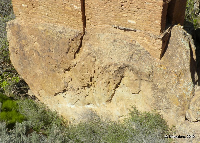
According to NPS literature, “Boulder House was built sometime after A.D. 1200. It appears that the tower was constructed without outside scaffolding. Each floor was built from the inside, one floor at a time, building upward.”

Detail of the foundation of Boulder House.

The structure on the left is called Tilted Tower, for obvious reasons. Sometime after the Ancestral Puebloan people left, the sandstone boulder it was built upon shifted and slipped sideways into the canyon. The upper stories of the tower fell on the boulder and into the canyon. To me, the incredible thing is that even a portion of it remains standing.

Tilted Tower. It almost looks like someone came along with a gigantic saw and cut the end off of that boulder!

Photographs taken on May 19, 2010.

Friday, June 04, 2010

Hovenweep :: Square Tower Group

I found Hovenweep National Monument to be a fascinating place. Viewing the multi-storied towers perched on the canyon rims and balanced on boulders, I was amazed by the structures and by the people who had built them. Experts at masonry and engineering, the builders used the rock slabs for foundations and the walls of the structures were laid down over the uneven surfaces, rising, in some cases, to heights of several stories.

Why were they built on the rocks? Why were they built in a variety of shapes – squares, ovals, circles, and D-shaped? What was the purpose of the buildings? What happened to their builders?

According to literature from the National Park Service:
The towers of Hovenweep were built by ancestral Puebloans, a sedentary farming culture that occupied the Four Corners area from about A.D. 500 to A.D. 1300. Similarities in architecture, masonry and pottery styles indicate that the inhabitants of Hovenweep were closely associated with groups living at Mesa Verde and other nearby sites.

The ancestral Puebloans prepared their land for cultivation much like farmers do today. They created terraces on hillsides, formed catch basins to hold storm run-off, and built check dams to retain topsoil that would otherwise wash away. Storage granaries under the canyon rims protected harvests of corn, beans and squash for later use.

Many theories attempt to explain the use of the buildings at Hovenweep. The striking towers might have been celestial observatories, defensive structures, storage facilities, civil buildings, homes or any combination of the above. While archeologists have found that most towers were associated with kivas (Puebloan ceremonial structures), their actual function remains a mystery.

By the end of the 13th century, it appears a prolonged drought, possibly combined with resource depletion, factionalism and warfare, forced the inhabitants of Hovenweep to depart. Though the reason is unclear, ancestral Puebloans throughout the area migrated south to the Rio Grande Valley in New Mexico and the Little Colorado River Basin in Arizona. Today's Pueblo, Zuni and Hopi people are descendants of this culture.
The Square Tower Group, located in and around Little Ruin Canyon, which is a short walk from the visitors center, has the largest collection of ancestral Puebloan structures at Hovenweep. The remains of nearly thirty kivas have been discovered as well as a variety of other structures. They think that it is possible that as many as 500 people occupied the Square Tower area between A.D. 1200 and 1300.

The Stronghold House as seen from across the the canyon, from the south side.

These are the same two buildings in the previous photo, taken from a slightly different angle. Using the zoom distorts and compresses the view somewhat.

Two towers, looking northwest.

The same two towers, looking northeast.

Detail showing the stonework.

Hovenweep House, the largest structure in the area, along with several outbuildings. As seen from the south side of the canyon.

Hovenweep House, on the edge of the canyon. Looking to the east.

The Square Tower. Perched on a boulder, at the bottom of the west end of the canyon.

Ruins Canyon, looking east. The two towers are just below the rim of the canyon near the center of the picture. Several other structures dot the landscape, almost blending in with the boulders.

Photographs taken on May 19, 2010.

Thursday, June 03, 2010

Hovenweep National Monument

In the southeast corner of Utah and southwest corner of Colorado lie the ruins of several prehistoric, Puebloan-era villages in a place called Hovenweep. It is not far from the Four Corners Monument, which is the only place in the United States where four states - Arizona, New Mexico, Utah, and Colorado - come together and where a person can be in four states at the same time. But you can't do that until July because it is closed for renovation!

In the early evening light at Hovenweep, the structures within the canyon were not easily seen. Those on the rim of the canyon took on an other-worldly aura, especially when viewed in the last rays of the setting sun. Still, I stood looking in awe of those who had built them and looked forward to tomorrow when they could be seen better in the light of day!


Photographs taken on May 18, 2010.