Showing posts with label Big Bend. Show all posts

Wednesday, March 13, 2013

Big Bend Revisited :: Boquillas Canyon Trail

Sunday, March 3rd - - On my last day at Big Bend, I decided to hike the Trail to Boquillas Canyon, going in mid-morning to avoid the heat that was coming later. It was forecast to get near 90 degrees today, the hottest day yet.

It is a short trail - only 1.4 miles round trip - but it takes you up a rather large hill, then back down the other side.

The trail provides some nice views. Blending into the distant landscape is the the town of Bouquillas. If you look closely you can see a few white buildings in the center of the photo, just beyond the green area. Actually, the town is not far from the Rio Grande Village area.

One of the many bends in the river. The man in the foreground was fishing. I wonder if he caught anything?

On my previous visit in February 2010 I had the pleasure of hearing "Victor, the singing Mexican" but he was on the other side of the river then. There were several bottles set out along the trail, asking for donations for singing. Some bottles were identified as Jesus, others as Victor. This man was standing beside one of the bottles identified as Victor but when I asked his name, he said Jesus! Anyway, while I was in the canyon area, I was being serenaded.

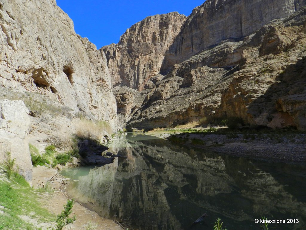
The path leads you to the river... 

The canyon walls go straight up, and the river disappears around the bend.

It was cool in the canyon, but as I walked back out, I could feel the heat. It was indeed going to be a hot day and it felt good. A few of the buildings in the town of Boquillas can be seen in the far right corner of this photo. As always, double-click to view a larger version.

Published under a Creative Commons License.
Becky Wiseman, "Big Bend Revisited :: Boquillas Canyon Trail," Kinexxions, posted March 13, 2013 (http://kinexxions.blogspot.com/2013/03/big-bend-revisited-boquillas-canyon.html : accessed [access date])

Tuesday, March 12, 2013

Big Bend Revisited :: Cerro Castalon

Saturday, March 2nd - - In English, Cerro Castalon is called Castolon Peak. Whatever you call it, it dominates the landscape in the Castalon region in the southern realms of Big Bend National Park.

The southern view is the most photogenic side of Cerro Castalon. As you drive in from the north the peak appears from out of nowhere as you crest one of the many hills. The road winds through the area with virtually no place to pull off to get a picture.

On my way back from Elena Canyon, I shot this through the front window, stopping in the middle of the road. There wasn't much traffic... Shooting through the windshield adds a greenish tint to photos so I converted it to black and white and adjusted the contrast a little.

At the base of the peak, on the western side, is a pull-out. This too, is Cerro Castalon though it doesn't look quite so impressive from this vantage point... which just goes to show, you need to look at everything from different perspectives!

Published under a Creative Commons License.
Becky Wiseman, "Big Bend Revisited :: Cerro Castalon," Kinexxions, posted March 12, 2013 (http://kinexxions.blogspot.com/2013/03/big-bend-revisited-cerro-castalon.html : accessed [access date])

Monday, March 11, 2013

Big Bend Revisited :: Santa Elena Canyon

Saturday, March 2nd - - From Rio Grand Village to Santa Elena Canyon is about a 55 mile, very pleasant scenic drive, through the varied terrain of Big Bend National Park. It's worth the drive.


There is not much water flowing through this area of the Rio Grande. On the right you are in the United States, on the left is Mexico. You could easily walk across the Rio Grande, but it is definitely not recommended. In fact, it is illegal to do so.

A trail goes up the canyon wall in a series of short switchbacks on the far right, then takes you on back into the canyon a short distance. The temperature was reaching into the 80s and I had done the hike three years ago so chose not to do it this time.

This is the creek that was full of water during my last visit. You have to cross it to get to the trail. Going across was a bit of challenge then, not so now.

Yep, it was pretty dry. Some of those cracks were 3-4 inches deep.

Published under a Creative Commons License.
Becky Wiseman, "Big Bend Revisited :: Santa Elena Canyon," Kinexxions, posted March 11, 2013 (http://kinexxions.blogspot.com/2013/03/big-bend-revisited-santa-elena-canyon.html : accessed [access date])

Sunday, March 10, 2013

Big Bend Revisited :: Torrey Yucca

Thursday, February 28th - - As I was driving from one place to another, I kept seeing this strange looking plant. It stood anywhere from four to six feet in height. Usually the bottom half was still brown and dry looking, but on the upper portion were long green spikes and a huge flowering head. There are quite a few pull-outs along the park roads but it seemed there weren't any of these plants in those areas. I finally found a pull-out with several of them somewhat near the road, while on my way to Boquillas Canyon.

This is the Torrey Yucca... The University of Texas at Austin website has some information about the plant as well as some pretty neat photos.

Many of the specimens I saw had only one flowering clump adorning the top, but this one, as well as others, are sporting two.

What appears at first glance to be one huge flower turns out to be a clump of many small flowers, in varying stages of development.


Published under a Creative Commons License.
Becky Wiseman, "Big Bend Revisited :: Torrey Yucca," Kinexxions, posted March 10, 2013 (http://kinexxions.blogspot.com/2013/03/big-bend-revisited-torrey-yucca.html : accessed [access date])

Saturday, March 09, 2013

Big Bend Revisited :: Boquillas Overlook

Thursday, February 28th - - It was late afternoon when I drove out to Boquillas Overlook on the east side of Big Bend National Park. The road to Boguillas Canyon is a mile or so from Rio Grande Village. It is a short but somewhat "challenging" drive with lots of twists and turns along the way.

Signs are posted in certain areas of the park regarding Mexicans coming across the river to sell trinkets and craft items "for the support of the Boquillas school." The signs warn you that purchasing these items is illegal. However, there is apparently enough income gained that they continue to present their wares for sale.

 At Boquillas Overlook there were several boulders used for displaying the goods for sale. The sign reads "Art, Craft, for Sale please purchase to Help Boquillas Mexico school kids Donations are aseptable. Walking Sticks - 6, Scokoypions - 6, Road runner - , Ocotillos - 5..."

All of the displays were selling similar items... walking sticks, and scorpions and road runners made from wire and beads.

When I arrived at the overlook, there was a Mexican walking away from the area. He waved, said hello and something else that I didn't understand, then walked down the hill and away toward the river.

I nonchalantly started taking pictures... Looking to the East...

Looking to the West...

And the view to the south... Oh, my - Across the river a boat sits on the shore and to the right, under a clump of trees was a group of men...

A close-up of the men lounging in the shade of the trees. I didn't mention earlier, that another sign at the turn-off to Boquillas Canyon warned of numerous recent vehicle break-ins. We were told to make sure our vehicles were locked and that valuable items were hidden away. I wondered if these were simply men lounging about or were they bandidos? Ah, the mind can take you off into some strange places...

Published under a Creative Commons License.
Becky Wiseman, "Big Bend Revisited :: Boquillas Overlook," Kinexxions, posted March 9, 2013 (http://kinexxions.blogspot.com/2013/03/big-bend-revisited-boquillas-overlook.html : accessed [access date])

Friday, March 08, 2013

Big Bend Revisited :: Chisos Basin

Thursday, February 28th - - It was about 180 miles from Seminole Canyon State Park to the northern entrance of Big Bend National Park. At 10:30 when I finally left Seminole Canyon, the temperature was 57 degrees with a few clouds, lots of blue skies and sunshine.

Once you get to the entrance of Big Bend, it is another 30 miles to the visitor center at Panther Junction, then another 24 miles to the Rio Grande Village area in the eastern side of the park. The road to Rio Grande Village is mostly downhill - it takes you into the "lower" portion of the park - and the temperature went from a cool 60 degrees to a much warmer 69. Yeah, that was nice!

I picked out my campsite, which was to be "home" for the next four nights. The campground was not full by any means and there were plenty of sites to choose from whether you wanted one "out in the open" or more secluded along the southern section (as I did). As usual in most National Parks there are no hookups for electricity or water in the "main" campground. However, Big Bend does have an "RV" area with hookups but it is pretty much a parking lot.

Friday, March 1st - - It got quite cold during the night, as expected, and it sure would have been nice to have a little heater to take the chill out of the air. Instead, I just stayed in the sleeping bag a little longer than usual...

It was still chilly when I finally got up, but it was quite comfortable sitting in the sunshine and eating my breakfast. I decided to drive up to the Chisos Basin area, stopping along the way for some photos...

 Looking to the West, from about 5 miles east of the Panther Junction visitors center.

 Somewhere along the lower portion of the road to Chisos Basin. It's about 8 miles once you turn off the main road to Chisos Basin. The road goes uphill, winding its way through the mountains, gaining several thousand feet in elevation, and making several hairpin turns. The road is not recommended for vehicles pulling trailers longer than 20 feet or for RVs more than 24 feet long.

I don't think there have been any recent bear sightings, but mountain lions were seen in several areas earlier in February. One was even sighted along the Window View Trail not far from the visitors center and the Chisos Lodge.

 Once you get to the highest point along the highway, you then start going down into the basin area. Hidden out of view are the campground and Chisos Mountain Lodge.

 Traveling a little further along the road, the campground area comes into view. I stayed there for five nights on my visit in February 2010. The vehicles look so tiny compared to the mountains surrounding them.

The view through the "window" from the Window View Trail near the visitor center and Chisos Mountain Lodge.

My visit this year would be very different than it was in 2010, and shorter. My legs can't handle the long hikes as well as they did three years ago and I am pitifully out of shape. Nevertheless, the visit this year was very enjoyable and more relaxing, and of course, there will be more posts/photos to come.  Below is a list of the posts from the 2010 visit I thought you might enjoy reading again (or perhaps, for the first time) - I was far more adventurous then!

Published under a Creative Commons License.
Becky Wiseman, "Big Bend Revisited :: Chisos Basin," Kinexxions, posted March 8, 2013 (http://kinexxions.blogspot.com/2013/03/big-bend-revisited-chisos-basin.html : accessed [access date])

Sunday, March 21, 2010

Big Bend :: Santa Elena Canyon

One of the main attractions of the Castolon area is Santa Elena Canyon and the trail that leads you a short distance into the Canyon.

On my first afternoon at Castolon, I drove the eight miles to the end of the road and ventured down to the river. To get to the canyon trail you first have to cross a small stream that meets the Rio Grande. Depending upon how much rain there has been, or whether water has been released upstream, the crossing can be between impassible or merely a walk across a dry stream bed.

On this day the stream was flowing, with perhaps 2-7 inches of water where it joined the Rio Grande but upstream it was thick, gooey mud. I put on my old shoes and waded across, carrying with me a pair of dry socks, which I changed into on the other side. If you are careful in choosing the path across the stream you can cross without hardly getting wet. I was more successful (less wet) on the return trip across.

Santa Elena Canyon was forged through the eons by the waters of the Rio Grande. Mexico is on the left and the United States on the right. Also on the right is the small stream that joins the Rio Grande that must be crossed to get to the trail.

The view from up above, at the highest point of the trail. The Chisos Mountains off in the distance. The small stream on the left merges with the Rio Grande on the right.

The trail drops down to the river, goes into the canyon about half a mile, and ends just on the other side of the big boulder in the center of the picture. The walls of the canyon, at that point, go straight up from the river.

The next morning I returned for another picture of the Canyon. The water level of the stream had dropped significantly overnight but the stream bed was still quite muddy.

Photographs taken March 1, 2010 and March 2, 2010.

Saturday, March 20, 2010

Big Bend :: Castolon

Back in the early 1900s, the Castolon area was under cultivation. It was interesting to look at the area now and imagine green, luscious fields filling the valley, made possible through irrigation by pulling water away from the Rio Grande. Where now you see cactus, mesquite and other desert plants there were acres of cotton, sorghum, alfalfa, corn, wheat, and melons. Actually, it is beyond imagining. It really is hard to believe that someone could actually farm in that rocky, sandy soil.

The remains of several houses of the farming families are still standing and can be seen on a short half-file walk about seven miles from the campground. One such farmhouse is that of James and Melissa Belle Sublett, settlers who came to Castolon in 1913. According to a sign at the site, James is recognized for introducing mechanized farming into Big Bend and also installed the area's first irrigation system supplied by a water wheel. By 1918, he owned nearly 3,000 acres of land in the area.

Built on the side of a hill, the walls of the Sublett home are all that remain. The back wall had no windows since it faced the hillside.

The remaining walls of the Sublett home.

The view from the front of the Sublett home. As beautiful as it can be sometimes, I'm not sure it would be worth it to me to live in such a place. For some it obviously is, but I'm not one of them!

The Dorgan House, shown below, was built in the 1930s by Albert W. Dorgan and his wife Avis Ann. The adobe home had large windows at the front and a double fireplace that opened into the central living area. In 1938 the Dorgans vacated this property and in 1941 leased it to A. F. Robinson who opened a resort hoping to benefit from the new Big Bend National Park. The resort was a failure and the Dorgans sold it for inclusion in the park.

In the early years of the park, historic structures like the Dorgan and Sublett homes, were either destroyed or allowed to deteriorate because they were not thought of as part of the natural scenery.

The Dorgan house was built on a mesa, which overlooked the Sublett home.

The fireplace in the Dorgan home, made of stone, petrified wood, and adobe bricks, dwarfs the remains of the house. It stands about 10 feet tall.

A detail of the adobe walls of the remains of the Dorgan home.

The ruins of the Sublett home, in the center of the picture, appears insignificant in context of its surroundings. The mountains behind the home are in Mexican territory. The Rio Grande flows at the base of those mountains, several miles from the Sublett home.

The Subletts and Dorgans would have witnessed many such mornings as this. In their struggles to make a living, I wonder if they saw the beauty around them.

Photographs taken March 1, 2010 and March 2, 2010.

Friday, March 19, 2010

Big Bend :: Cerro Castellan

After four nights at Rio Grande Village, I drove to the Castolon area and the Cottonwood Campground, at the south end of Big Bend National Park, on March 1st.

It is a very scenic drive of about 60 miles from Rio Grande Village to Castolon. You nearly circle the Chisos Mountains coming up from the east, passing by on the north, then following them along their western side. To say that the Chisos Mountains dominate the central landscape of the park would be an understatement.

The Chisos Mountains. From the northeast side, 15 miles or so from Rio Grande Village.

The high peak on the left is the South rim. This was taken at on overlook a few miles south of Castolon, using the 7x magnification of the zoom lens. The informational sign at the overlook stated that the South Rim was 16 miles away!

However, Cerro Castellan (also called Castolon Peak) is “the landmark” of the Castolon area, which was a small community whose name is believed to be a corruption of the spelling of Castellan.

The view from about seven miles south of Castolon. The Chisos mountains in the background, Cerro Castellan on the right, and the Rio Grande winding its way through the area.

Cerro Castellan, highlighted by the last rays of the sun at the end of another beautiful day. I stood out in the chilly wind for over an hour waiting and hoping for this moment! It was magnificent and lasted only a few seconds. It was also well worth the time and the cold hands!

Photographs taken on March 1, 2010.

Wednesday, March 17, 2010

Big Bend :: Hot Springs Trail

One of the easier trails in the Rio Grande Village area is the Hot Springs Trail, which takes you three miles through the hills, canyons, and desert to, where else, Hot Springs! But when the river is high, like it was on this day, the Hot Springs are flooded. So, no relaxing in the springs when you get there! When the river is low, the water from the Springs runs clear and warm. The Springs were developed in the late 1920s. There was a lodge, store, and the Spring House where visitors would soak up the powers of the mineral hot springs. The foundation is the only thing remaining of the Spring House now. The lodge and store buildings still exist though they are no longer used.

The weather forecast was for temperatures in the low 60s so I put on a sweatshirt and nylon windbreaker, packed my little bag with “energy” food to eat along the way, grabbed some water, my hat and walking stick and was on my way.

The trailhead is on the opposite side of the Village, about two miles away, so I drove the van over. After passing through the grove of green cottonwood trees the trail started up. And up. It was uphill for the first 3/10 of a mile. And not just a gradual uphill slope, but steep switchbacks that I am sure have tested many a soul, mine included! As it turned out, this was actually the hardest section of the trail (as far as going uphill, anyways).

The view from the overlook, after you have navigated the first 3/10 of a mile, uphill. It sure seemed like more than 3/10 of a mile to me!

Probably about half way out, there were three hikers making the return trip. They were the first people I had seen since starting out. Of course, they said the trek was worth it. That's what everyone says about every trail it seems. A short while later when I looked back at where I had been, I saw another lone hiker coming my way. In an odd way, it was somewhat comforting to know that someone else was behind me.

It wasn't long before the lone hiker caught up with me. I'm a slow walker, stopping often along the way. His name was Larry and he was from Wisconsin. We chatted for a minute or two and then he was on his way. I'd see him every now and then, up ahead. About this time, it was getting hot. Much hotter, it seemed, than the 60 degrees that had been forecast. I had already taken off the windbreaker and was considering the removal of the sweatshirt. Instead I pulled up the sleeves. Oddly enough it was cooler with the sweatshirt on than with the bare skin exposed to the direct sunlight.

These were growing in what appeared to be solid stone, right on the edge of the canyon. They were about 8 inches tall.

The desert sometimes appears lifeless and barren, but it is really far from it. Life is all around if you just stop to look for it.

Up and down. Following the worn trail of dust and stones. It goes on and on. The Hot Springs are down there, down by the river. Close, but oh so far away!

Getting closer. The Hot Springs are just in front of that sandbar sticking out into the river.

Looking back. At where I'd been.

I heard someone yelling but couldn't make out what they were saying. It was Larry, the lone hiker. He waited until I caught up with him then told me that he had been trying to tell me about the huge spiral fossil in the path. But I had seen it.

The fossil was at least a foot in diameter. And it was right on the pathway. You can't help but step on it as you go down the trail.

Larry and I walked together to the end of the trail. There were picnic tables beneath the shade of a huge palm tree. Upon closer inspection, the tree was made up of five palm trees clumped together, it was amazing. Even more amazing is the fact that I didn't get a picture of it! Larry and I sat beneath that aged tree and ate our lunch. We talked about everything and about nothing. Soon he was on his way back. I stayed and rested for another fifteen minutes before leaving.

The walk back seemed much harder than it was going out. There was very little shade. I found one spot where a rock overhang provided a bit of relief. It helped. I didn't think I'd have enough water so I would take small sips, just enough to wet the lips. It helped.

The last uphill stretch was the hardest. I knew I was getting close to the overlook. I knew I'd made it! And then I heard a voice. Larry had waited for me there, at the overlook. I thought, how sweet. And I thanked him. He said he was concerned since I was alone, he'd been keeping an eye out for me. He said that if I was feeling anything like he was – exhausted – that it would be nice to take a break before tackling that last downhill section.

I found a rock to sit down on. It happened to be in front of a trail sign, which was casting it's shadow. Ah, shade, just enough to get me out of the sun for a few minutes. I drank the remainder of my water and was thankful for it, as warm as it was and as awful as it tasted, it was delicious.

After about 15 minutes of rest, we continued on down the hill, meeting several other people coming up who were just going to the overlook. At the trailhead Larry and I said our goodbyes. He took the picture of me below. Not a glamorous getup, but it got the job done! If I look hot and tired, it's because I was...

Rather pleased with myself, I slowly walked to the van, pulled out a bottle of cool water and sat down in the shade of one of those glorious cottonwood trees! Then I went to the camp store and had an Ice Cream bar! Well, to be honest, I had two!