Showing posts with label Colorado. Show all posts

Monday, September 15, 2014

Where Have I Been?

My apologies. I have not been keeping y'all up to date very well, have I? So far this trip I've had internet access just one day. It's been kind of nice being "disconnected" from the world for a while. I've been keeping to the "back roads" of America and not eating at 'that' fast-food joint...

Today is a prep day and a day of relaxing. Sorting through 'stuff' to make sure everything that will be needed in the next 17 days is at hand and hoping that what I've decided to take will all fit in the 'dry bag' that will be provided. Tomorrow we head up to Lee's Ferry for the night with departure Wednesday morning. Excitement is in the air!

Below are some pictures of the places I've been in the past week.  More to come later...

Great Sand Dunes National Park northeast of Alamosa, Colorado.

Black Canyon of the Gunnison (Colorado).

And there was more than cows on the road... poor Van Dora was in need of a bath after this stretch of highway...

A Ranger pointing out the petroglyphs on a guided tour at Hovenweep National Monument (in Utah, west of Cortez, Colorado).

Early evening in Grand Canyon National Park, Arizona.
~ ~ ~ ~ ~ ~ ~ ~ ~ ~
Note: The page Grand Canyon Raft Trip lists all of my posts published about this Grand Adventure!

Published under a Creative Commons License.
Becky Wiseman, "Where Have I Been?," Kinexxions, posted September 15, 2014 (http://kinexxions.blogspot.com/2014/09/where-have-i-been.html)

Sunday, June 19, 2011

Over the Rockies


The Rock Cut Nature Trail is a short paved trail that goes up (and up) from the parking area.


Still snow-covered in areas, the slipperiness and elevation made for difficult walking at times.


Looking toward the west from the top of the Rock Cut Nature Trail.


And, looking toward the east.


Traveling on down the highway and over the summit, the scenery changes drastically. The snow is gone and the hazy skies return, as did warmer temperatures!

No offense to those living in eastern Colorado and southern Nebraska but after crossing the Rockies, the scenery was somewhat less interesting.

I made it “safe and sound” back to Indiana where I'll be until after the 4th of July weekend. And then? Well, time will tell...

Saturday, June 18, 2011

Traversing the Trail Ridge Road

On my “speedy” drive back to Indiana from Salt Lake City (1600 miles in 4 days) I chose to go through Rocky Mountain National Park. I knew I wouldn't have any time to spend there but also knew that it would be a nice drive!

Trail Ridge Road, the road through Rocky Mountain National Park, opened on June 7th, just three days before I arrived. The highest continuous paved highway in the United States, connecting the towns of Estes Park on the east side and Grand Lake on the west, it reaches an elevation of 12,183 feet and affords some spectacular views.


This winter, Mother Nature, dumped a lot of snow on the area. More than she has in 30 years. The amount of snow that the snowplow operators faced when they began clearing the road in April along with a big snow storm the last week of May, which produced 17 foot drifts in some areas, delayed the opening of the road. It is usually open by Memorial Day weekend.

I was fortunate that it was open by the time I went through. I was also fortunate that it was a most beautiful day!


A big snow blower at the Alpine Visitor Center.


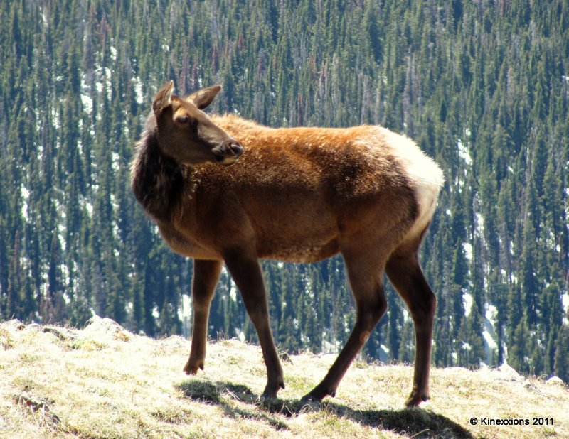
This fellow was about 15 feet off the road.


If you look closely, you can see guardrails along the road on the right-center side of the picture. This is looking back from the Rock Cut parking area.

Friday, June 17, 2011

Heading Back East

Leaving Salt Lake City on the morning of June 9th, I took I-80 through the Wasatch Mountains toward Park City where I picked up U.S. 40, which is a very scenic route. I stopped for the night in Hayden, just before getting into the higher elevations of the Rocky Mountains.


The next morning I passed through Steamboat Springs and stopped for pictures at one of the lakes. This is where the climb into the Rockies really begins. Because of the record amount of snowfall this winter, the rivers and lakes are full to overflowing.


If this lake gets much fuller, these houses will have some problems!


Somewhere in the mountains along U.S. 40

Several hours later, just before entering Granby, I turned off of U.S. 40 onto U.S. 34, which is the highway that goes through Rocky Mountain National Park.


Approaching Rocky Mountain National Park on U.S. Highway 34


North of Grand Lake


And onto the Trail Ridge Road (still U.S. 34)


At the first parking area inside the park. The snow was several feet above my head.

Thursday, May 19, 2011

Hovenweep Revisited

Wednesday, May 11th - - My stop for the night was at Hovenweep National Monument, just inside the Utah border, about 45 miles west of Cortez, Colorado.

Yes, I went through Colorado rather quickly. Blame the weather. Call me a wimp if you will, but these extemes in temperatures are not easy to handle. Anyway, I'll be back someday. (I did spend several days in Colorado last year at Mesa Verde National Park.)

Earlier in the day, I had checked the weather forecast for several places along my route. The forecast for Hovenweep was quite favorable and I knew from my visit last year that they had a nice campground. The temperature going through Cortez wasn't much better than it had been after going over the San Juan Mountains but as I continued westward it warmed up to a most comfortable 66 degrees.

I also spent several days at Hovenweep last year and wrote about the National Monument, The Square Tower Group, and The Holly Group in detail. Since the weather was nice, I walked the two-mile trail around and through the canyon to view the Square Tower Group once again. The sun was playing hide-and-seek with the clouds so I waited for some shots until the sun decided to come out. It wasn't an extremely bright light like it was last year and I'm using a different camera so the pictures have an altogether different feel to them.


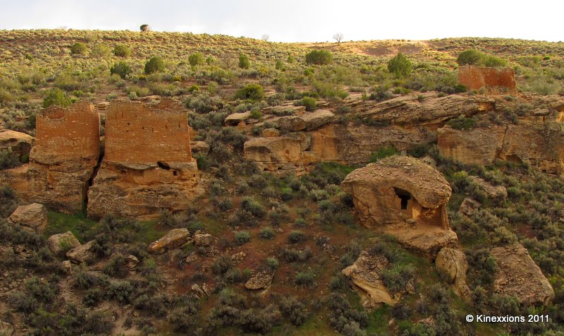
The largest structure in the Square Tower Group, which is near the campground, is the Hovenweep House. It includes several outbuildings. Here it is seen from the south side of the canyon.


From the north side of the canyon looking at the Twin Towers, Boulder House, and Rim Rock House. Unless you know it's there, it is hard to tell a canyon exists in just a few steps.


A closer look at the Twin Towers, Boulder House, and Rim Rock House.


An even closer look at the Twin Towers (above) and Boulder House (below).


I still find this place to be fascinating, especially how and why these structures were built.


Mother Nature put on another magnificent show at the end of the day.


I've said it before and I'll say it again - sometimes the best sunset pictures are taken looking toward the east (or any direction other than west)! Rain was blowin-in-the-wind and captured the colors of the sun's fading rays.

Wednesday, May 18, 2011

Over the San Juan Mountains

Wednesday, May 11th - - After a little stop in Alamosa, about 25 miles southwest of the Great Sand Dunes, I continued west on U.S. 160/285.


I was somewhat alarmed at what I saw down the road after leaving Alamosa. I did get into some rain and, at the higher elevations, some snow. But it wasn't really all that bad. The temperature was 49 degrees with a fairly strong wind. By the time I got to the summit at Wolf Creek Pass, (elevation 10,685 feet) the temperature had dropped to 25 degrees. It warmed back up once over the mountains.


On the way up to the summit at Wolf Creek Pass.


On the other side of the San Juan Mountains.


Love this! A nice shot purely by chance! It helps when you roll down the window and the sun comes out for a second.

Tuesday, May 17, 2011

The Dunes in the Morning

Wednesday, May 11th - - The temperature didn't get as low as I had feared it might but it was a blustery 40 degrees when I awoke at 6:30 this morning and saw heavy clouds hovering over the area. The forecast was for a 60% chance of rain. With the cold and gloomy prospects for the weather, I decided to move on with the hope that one day I will return. Off in the far distance, to the southwest in the valley beyond The Dunes, there was sunshine. Some scattered clouds too, but not like the gray clouds overhead.


The Dunes are held captive by the Sangre de Christo Mountains. The campground is to the right of where the dunes drop off (just right of the center of the photo). The sun was coming over the mountain on the right and maybe it would have burned off the clouds and fog, but then again maybe not.


The sun came through the clouds briefly on my way out of the park. I love how the light moves over The Dunes.


A closer look, half in light and half in shadow.


The shape of The Dunes mimic the peaks of the mountains behind them.


To my amazement and delight, this image brings it all together... the light, The Dunes, the mountains, the clouds, the moment. There for an instant. Then it was gone. I stood in awe as the sun rolled over the dunes. It was incredible to watch.

Monday, May 16, 2011

I'm Not in Kansas Anymore!

Tuesday, May 10th - - It never crossed my mind that I'd spend nearly six days in Kansas, much less enjoy most of it! Crossing over into southeastern Colorado the countryside looked much the same as it had in western Kansas. Fields were under cultivation to begin with but as I ventured further south and west there were more vast expanses of prairie.

However, within a few hours, the view changed dramatically. Mountain peaks touched with a dusting of snow could be seen off in the distance. It wasn't long before they loomed much larger and closer. With the change in view came a dramatic change in daytime temperature – from a high in the upper 90s to a high in the mid 50s. Thank goodness that, unlike the air conditioner, the heater in the van works!


West of Walsenburg, Colorado on U.S. Highway 160/285.

My destination for the night was the Great Sand Dunes National Park and Preserve, near Alamosa. I had visited there once before, way back in May of 1979.


This time, Mother Nature was definitely not cooperating with me. The further west I traveled, the cloudier it got. Once at The Dunes, the sun would occasionally peek out from behind the clouds, but even then the lighting wasn't that great. This is the view from my campsite. The base of The Dunes is about a mile and a half distant.


The image above and those following have been modified. I was going to say “enhanced” but that is entirely dependent upon who is viewing the images. Since you aren't going to see the originals, suffice to say that I think these are an improvement over the originals, considering the lighting conditions at the time.


Human figures add a little perspective on the size of these dunes. They (The Dunes) truly are magnificent.


And from what I remember from back in 1979, they are extremely difficult to walk on. I did go out to the base of The Dunes but simply did not have the energy or stamina to go any further. Besides, it was getting late in the evening, a strong wind was blowing, and it was cold!


The quality of light was pitiful, and it was nearly gone, but the views were still awesome even though they can't truly be captured by the camera.

Tuesday, June 08, 2010

Mesa Verde :: Spruce Tree House

The third cliff dwelling that I visited while at Mesa Verde was Spruce Tree House, which does not require a ticket as it is a self-guided tour. Rangers are on-site at all times to answer questions and keep and eye on visitors.

It is the third largest of the cliff dwellings and contains about 130 rooms and 8 kivas (kee-vahs) built into a natural alcove 216 feet wide at its greatest width and 89 feet at its greatest depth. It is thought to have been home for about 60 to 80 people.


The black areas on the underside of the rock were caused by smoke from the fires they used to cook with and keep warm.