Showing posts with label Yellowstone. Show all posts

Friday, September 16, 2011

Yellowstone :: Mammoth Hot Spring Terraces

Friday, September 2nd - - The temperature was even cooler this morning – a rather brisk 29 degrees! There was some frost on the rear window. I drove down to Yellowstone Lake and found a drive that went along the shoreline for a little ways.


The sun had already risen above the mountain tops and there was a lot of haze in the sky. It was the perfect place for breakfast on this, my last morning in the park!

I decided to revisit the Mammoth Hot Springs Terrace, specifically the Upper Terrace where there was actually a road that wound its way through the area. Driving the “long way” around, going south then west then north, it took me nearly 3 hours to reach the Terraces. Of course, I did stop a few times along the way...

And, wow, what a difference a day makes! With a good nights rest and better lighting conditions, the terraces looked completely different than they did the previous day.


Prospect Spring, which flows into the Highland Terrace, and those microscopic thermophiles that make it so colorful.


Leaves and twigs fall into the shallow waters and are transformed by the minerals in the water.


Thermophiles (those heat-loving microorganisms) create tapestries of color where hot water flows among the terraces. Colorless and yellow thermophiles grow in the hottest water; orange, brown, and green thermophiles thrive in cooler waters. The colors also change with the seasons.


The terraces are formed by a combination of factors: The hot water beneath the surface dissolves carbon dioxide that makes a solution of weak carbonic acid. As the solution rises through rock, it dissolves calcium carbonate, the primary compound in limestone. At the surface, the calcium carbonate is deposited in the form of travertine, the rock that forms the terraces of Mammoth Hot Springs.


There is a constant state of flux as the water moves over the surface and the terraces grow.


Over the years, the terraces grow and expand, encroaching on areas where trees had thrived.


The above photo was taken when I visited the park in July 1979. It is a lower angle and doesn't show as much of the “face” of the terraces but, with the position of the mountains in the background, I think it was taken in the same area as the next two photos.


Of course, 34 years have gone by, and some change was to be expected, but this is a lot of change! The Park Ranger stated that the boardwalk in this area has been moved back twice and will have to be moved again within a few years.


Growth and change, dependent upon the flow of water.


I was enthralled by the various colors of the pools of water in the smaller terraces.


And by what is left behind when the water no longer flows.


This visit to the Mammoth Hot Spring Terraces was the perfect ending to my short stay at Yellowstone National Park!

Thursday, September 15, 2011

The Grand Canyon of the Yellowstone

Thursday, September 1st - - With the campsite in shade and temperatures in the low 30s this morning I went and found a nice sunny spot in which to eat breakfast. Then it was off to see the sights!


Sometimes, I guess, Buffalo prefer an easy route to wherever they are going! They were frequently seen alongside and on the road, usually only one or two bison at a time.

My primary destination this morning was the Grand Canyon of the Yellowstone with its beautiful Lower Falls and Upper Falls. Located at the northeastern corner of the southern highway loop, the 40 mile drive from the campground took about two hours, with stops along the way at the Mud Volcano Area and Sulphur Caldron.


My first stop in the “Grand Canyon” area was Artist Point on the South Rim.


Artist Point provides stunning views of the 308-foot Lower Falls. It is, quite simply, breathtaking! The morning light along with a hazy sky enhanced the view allowing details in the sides of the canyon to show up, though the colors are somewhat muted.


A closer view of the Lower Falls.


And, even closer.


The colors of the canyon didn't show up clearly in the photos of the Lower Falls, but, oh my, how they “popped” when looking to the northeast! The fantastic colors of the north side of the canyon come from rhyolite and sediments that have been altered by hydrothermal action (i.e. hot water from springs that were active in years past).


The Upper Falls is not quite as impressive (only 109 feet) or photogenic as the Lower Falls but it was still worth the walk down a short trail to see it.


It was also easier to access the Brink of the Upper Falls from another short trail. The Brink of the Lower Falls was a strenuous trail that dropped 600 feet in a very short distance. I passed on that one but did go to the Brink of the Upper Falls, shown above.


The view from Inspiration Point, on the North Rim, looking to the northeast.


As I drove up to the northwest side of the park to the Mammoth Hot Spring Terraces, the clouds moved in.


I walked along most of the boardwalk trails in the lower terraces but my legs were getting a little wobbly by the time I made it to the upper terrace area. Whether it was from the lighting conditions or the fact that many of the springs in that area have gone dormant, I was disappointed with my visit there. The photos I took were rather blah.


The view from the front of the upper terraces was rather impressive though. On the drive back to the campground, I took the “shorter” route along the west side of the northern loop then cutting across to Canyon Village and the eastern side of the southern loop. It was still about a 75 mile drive back to the campground.

Wednesday, September 14, 2011

Yellowstone :: Grand Prismatic Spring

Wednesday, August 31st - - Upon leaving the West Thumb area I stopped to see Old Faithful. I waited a little over half an hour for the old fellow to erupt. I'll just say it was less than spectacular. Old Faithful can have eruptions that last from a minute and a half to over four minutes. I happened to be there during one of the short eruptions in which it does not reach its maximum height. The next eruption, 90 minutes later, would probably have been a long one but I decided to go on to the next site on my list of “must see” things.


This diagram shows the features within the Midway Geyser Basin, the largest of which is the colorful Grand Prismatic Spring.


The water from the springs and pools in the area eventually makes its way to the Firehole River flowing below. Even here you could feel the heat from the water as it passed by. The sulfur smell was quite strong also.


A boardwalk trail meanders through the area giving you an “up close” look at the pools and springs. This is at the lower edge of Excelsior Geyser, which is currently dormant.


A panoramic view of Excelsior Geyser from its northern side (as with all photos, double-click on the image to view a larger version). Water flows from the geyser pool, down the hill, and into the Firehole River.


Water from the Grand Prismatic Spring flows into the Excelsior Geyser.


A view of Excelsior Geyser from its southwestern side.


Looking to the west toward the boardwalk around Grand Prismatic Spring from the boardwalk on the west side of Excelsior Geyser. The water is only a few inches deep between the two features.


The Grand Prismatic Spring. Colorful tendrils are formed by the heat-loving microorganisms where the water flows over the edge of the spring.


Looking back toward Excelsior Geyser.


The Opal Pool. You can just barely see Firehole River in the upper center of the photograph and the mountains way off in the far distance.


It was late in the evening when I headed back to the campground. This photo was taken along the western side of the southern loop in part of the Hayden Valley – that's the Yellowstone River flowing through the valley.

It had been a great day despite a few quick moving rain showers. The temperature was in the upper 60s and lower 70s all afternoon – great weather for sightseeing and playing the tourist!

Tuesday, September 13, 2011

Yellowstone :: West Thumb Geyser Basin

Wednesday, August 31st - - After spending the night at one of the campgrounds in Buffalo Bill State Park west of Cody, Wyoming it was a relatively short drive (a little over an hour) to the eastern entrance to Yellowstone National Park. Then another 30 miles to the campground at Bridge Bay in the southeast portion of the east side. I had decided to give the park a “second chance” since simply driving through it last year just before the Fourth of July weekend. My visit this time was quite pleasant with less people, far less traffic, and much cooler temperatures!

After checking into the campground, which would be my “base” for two nights, I drove the southern loop through the park. My first stop was the West Thumb Geyser Basin, which overlooks Yellowstone Lake, the largest lake at high elevation (7,733 feet) in North America – it encompasses 131.7 square miles, is 14 miles wide and 20 miles long, with an average depth of 140 feet. In other words, it is HUGE! And beautiful, with the Absaroka mountain range on its eastern side.


The volcanic caldera at West Thumb contains many geothermal features including pools, springs, geysers, and paint pots. Above is a view of the central portion, which sits above the lake. The geysers, however, are currently in a dormant stage, thus no eruptions were seen.


The Abyss Pool is one of the deeper hot springs in the park, descending to a depth of 53 feet.


The trail guide states that Black Pool was, at one time, actually black. Cooler water temperatures allowed thick mats of dark green and brown thermophiles (heat-loving microorganisms) to grow in the pool, causing it to appear black. The water temperature rose during the summer of 1991, killing the organisms.


Walking alongside the pool on the boardwalk you could feel the heat from the hot water. At times, the steam rising from the pool was so thick you couldn't see the other side!


The water appears to be turquoise but it was so clear you could easily see portions of the bottom. There were several deeper areas – the “black holes” where the bottom could not be seen.


Interesting formations line the sides of the pool.


Constantly in a state of change, new features appear every day.


Hot water from Black Pool and other features in the area flows into Yellowstone Lake. The color variations are caused by those little thermophiles – microorganisms that thrive in the hot water.


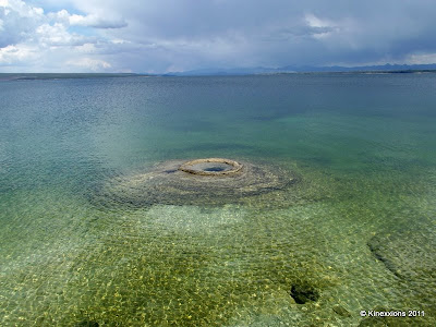
Along the shore of Yellowstone Lake is this feature, called Big Cone. It's difficult to tell from the angle of the photo, but the cone rises about 12 inches above the outer surface.


Boiling hot water bubbles up in the Big Cone.


Further along the path and completely surrounded by water is the “Fishing Cone” so called because Mountain Men told of catching a trout in the lake, swinging the pole around, dipping the catch in the boiling pool, and cooking the fish without even taking it off the line! Sometimes in spring and early summer the Fishing Cone is underwater due to the rising lake waters from snow melt.

Sunday, July 11, 2010

Teton-Yellowstone Drive-Thru

When I left Juniper Campground at the Ririe Reservoir, I decided to continue on US 26 over to US 89 in Wyoming, which goes through Grand Teton and Yellowstone National Parks. I greatly underestimated the amount of time that route would take! I had no intention of stopping for any length of time in either park (blasphemy, I know...) but thought it would be nice to drive through.

Teton National Park. The view from the Glacier View Turnout.

The drive was nice. Very pretty too, but it was also frustrating sometimes. Any kind of wildlife sighting resulted in traffic coming to a standstill. You'd think that people had never seen animals in the wild before! ;-)

First there were Buffalo. Not a big herd though, just a few scattered about.


Then there were Bears! Mama bear and her two cubs came up from the valley and crossed the highway, blissfully ignorant of the chaos and confusion they were causing! These pictures were taken through the windshield with the zoom at maximum magnification. I was about 15 vehicles away from the action.


There was also a moose (at least, that's what I think it was) with a large rack of antlers. I didn't get a picture of it though.

The place where I'll be staying in Montana is only two hours from the northern entrance to Yellowstone and I have every intention of spending a few days there, in the middle of the week when, hopefully, there are fewer people! Though with it being summer, there will probably be lots of people there no matter when I go.