Monday, September 22nd. After a long hike that exhausted the morning, as well as the hikers, we would traverse 13 miles of river this afternoon.
Two miles after leaving Rattlesnake Canyon we would come to our biggest and longest rapid thus far, Hance Rapid, which is rated 8-10 on the Grand Canyon Scale. First though we would go through Escalante Rapid and Nevills Rapid, rated 4 and 6 respectively.
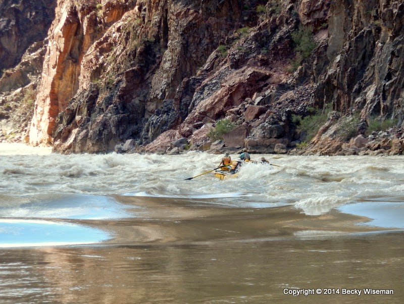
Like the approach to most rapids, Hance Rapid can barely be seen from the river. Even closer it doesn't look like much, but it is regarded as one of the most technical rapids in the Grand Canyon. Note the debris field on the left side of the river just in front of the raft.
As the river is altered by changing conditions so too are the rapids. Debris carried in by side streams during flash floods can easily, and often does, change the character of the rapids. The level of the water changes daily with the releases from Glen Canyon Dam, and that too affects the rapids. Each rafting group that goes through the Grand Canyon experiences each rapid differently than the groups that have gone before and those that will come afterward.
Hance Rapid, one of the few rapids that can be seen from the South Rim, has gone through a dramatic change within the last 2 years. The above photo was taken from Lipan Point, 3.8 miles away on the South Rim, during my visit to the Canyon in March 2012.
On August 15, 2012 there was a flash flood that went through Red Canyon, which dumped a bunch of rocks and boulders into the Colorado River at the top of Hance Rapid. After we had made it through and were waiting for the other rafts, KJ related the story of how he was a witness to that once-in-a-lifetime event.
In the past few weeks I've looked at quite a few videos and photos of rafting in the Grand Canyon and came across
this video taken on August 15, 2012 by Michael Mayer.
The caption added to the video states: "We tied up the rafts to scout this rapid before going through. It started [to] rain.... REALLY HARD.... then as we were about to get back in the rafts, the hail started... we were pummeled with rather large hail for about 10 minutes preventing us from getting in the rafts... and that is when the flash flood came out of the side canyon. Can't tell from the video, but it was probably 6-10 feet deep, 50-60 feet wide, and ran for about 1/2 hour at an amazing speed, and sounded like a freight train as it filled the left side of the river with rocks forever changing the rapid. According to the river guides, this was a once in a lifetime event to witness, especially one this large.... and we were the first ones to go through the newly formed Hance rapid."

I wish I had thought to go over to Lipan Point and get a shot from the same spot as the previous photo (wasn't really thinking too far ahead at the time) but I did get this view of Hance Rapid taken at sunset on October 7, 2014 from Navajo Point, which is a short distance east of Lipan Point. The debris field - that v-shaped pile of rocks on the left side of the river - looks like it spans the entire width of the river but it really doesn't.
The paddle boat crew making their run through Hance Rapid.
Hance is one of those rapids that is really two-in-one. You get through the upper portion and into a slower section of water. Here the rafts that have gotten through wait to make sure there are no "swimmers" to pick up.
Below the relatively calm section after the main part of the rapid is another little rapid, sometimes called Son of Hance.
Looking back from KJ's raft, with Hance Rapid in the background. The debris field can just barely be seen on the right side of the river.
We take a few minutes to gather together and talk about the run through Hance.
And then, we continue on down the river. We have now entered "the Gorge" area of the Canyon. The wide-open expanses have been replaced with immense walls of rock 1.7 billion years old that shoot straight up out of the river.
Composed of shiny black schist and streaks and blobs of salmon-pink granite, sections of the canyon walls come in a variety of shapes and colors.
It's difficult to wrap your mind around the fact that we are passing through a layer of rock that is 1.7 billion, yes! Billion, years old.
Fred and Sue, riding in Tom's raft with Priscilla and Elana, are approaching Grapevine Rapid at mile 82, rated an 8 on the Grand Canyon Scale.
Almost there.
They're in...
A little further.
At this point, the camera gets dropped down into the front of my life jacket and I grab hold of the straps! It was a wild and super fun ride.
Everyone made it through safely.
The campsite at Cremation Fault is just around the bend. In addition to Hance and Grapevine rapids, we also went through Sockdolager (at mile 79), 83 Mile Rapid, Zoroaster (at mile 85) and 85 Mile Rapid (which is actually closer to mile 86). It was definitely an exciting afternoon!
~ ~ ~ ~ ~ ~ ~ ~ ~ ~
Note: The page
Grand Canyon Raft Trip lists all of my posts published about this Grand Adventure!
Published under a Creative Commons License.
Becky Wiseman, "Day 6 - Part 2 :: Rattlesnake Canyon to Cremation Fault," Kinexxions, posted November 2, 2014 (http://kinexxions.blogspot.com/2014/11/day-6-part-2-rattlesnake-canyon-to.html : accessed [access date])