Wednesday, May 11th - - My stop for the night was at Hovenweep National Monument, just inside the Utah border, about 45 miles west of Cortez, Colorado.
Yes, I went through Colorado rather quickly. Blame the weather. Call me a wimp if you will, but these extemes in temperatures are not easy to handle. Anyway, I'll be back someday. (I did spend
several days in Colorado
last year at
Mesa Verde National Park.)
Earlier in the day, I had checked the weather forecast for several places along my route. The forecast for Hovenweep was quite favorable and I knew from my visit last year that they had a nice campground. The temperature going through Cortez wasn't much better than it had been after going over the San Juan Mountains but as I continued westward it warmed up to a most comfortable 66 degrees.
I also spent several days at Hovenweep last year and wrote about
the National Monument,
The Square Tower Group, and
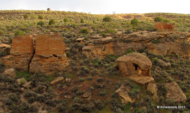
The Holly Group in detail. Since the weather was nice, I walked the two-mile trail around and through the canyon to view the Square Tower Group once again. The sun was playing hide-and-seek with the clouds so I waited for some shots until the sun decided to come out. It wasn't an extremely bright light like it was last year and I'm using a different camera so the pictures have an altogether different feel to them.
The largest structure in the Square Tower Group, which is near the campground, is the Hovenweep House. It includes several outbuildings. Here it is seen from the south side of the canyon.
From the north side of the canyon looking at the Twin Towers, Boulder House, and Rim Rock House. Unless you know it's there, it is hard to tell a canyon exists in just a few steps.
A closer look at the Twin Towers, Boulder House, and Rim Rock House.
An even closer look at the Twin Towers (above) and Boulder House (below).
I still find this place to be fascinating, especially how and why these structures were built.
Mother Nature put on another magnificent show at the end of the day.
I've said it before and I'll say it again - sometimes the best sunset pictures are taken looking toward the east (or any direction other than west)! Rain was blowin-in-the-wind and captured the colors of the sun's fading rays.